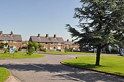
Eglwys Brewis
| Eglwys Brewis | |
| Glamorgan | |
|---|---|
 Elm Grove, Eglwys Brewis | |
| Location | |
| Location: | 51°24’49"N, 3°25’45"W |
| Data | |
| Post town: | Barry |
| Postcode: | CF62 |
| Dialling code: | 01446 |
| Local Government | |
| Council: | Vale of Glamorgan |
| Parliamentary constituency: |
Vale of Glamorgan |
Eglwys Brewis is a village and ancient parish in Glamorgan. It is located just to the north of the village of St Athan, south of Flemingston and north-east of Llantwit Major. Greenlands and St Mary Church lie to the north by road from Eglwys Brewis. The village primarily consists of residential estates which were originally built in the mid-20th century for service families stationed at nearby RAF St Athan. Nant y Stepsau flows in the vicinity.
Only a hamlet still in the early 20th century, Eglwys Brewis developed into a dormitory village with housing estates in the mid 20th century to accommodate for service families stationed at nearby RAF St Athan. Most of the houses on the estates surrounding the base were sold off.
Notable landmarks
Eglwys Brewis contains the Parish Church of St Brewis and Bethesda'r Fro Congregational Church. It contains one pub, Moonshine, formerly The Carpenter's Arms. The parish church, which became a Grade-II listed building on May 18, 2002 is a small stone church dates to the 12th-13th century with 16th century windows. [1] It contains a square stone castellated bell-cot at the western end of the nave and a Norman tub font and inscriptions.[1] To the east is RAF St Athan Golf Club.
References
- ↑ 1.0 1.1 "Vale of Glamorgan County Treasures". Vale of Glamorgan Council. http://www.valeofglamorgan.gov.uk/files/Living/Planning/Policy/County_Treasures/St_Athan.pdf. Retrieved 12 May 2012.
