Hessenford
| Hessenford Cornish: Rys an Gwraghes | |
| Cornwall | |
|---|---|
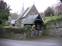
 St Anne's Church, Hessenford | |
| Location | |
| Grid reference: | SX307573 |
| Location: | 50°23’28"N, 4°23’2"W |
| Data | |
| Population: | 170 |
| Post town: | Torpoint |
| Postcode: | PL11 |
| Dialling code: | 01503 |
| Local Government | |
| Council: | Cornwall |
| Parliamentary constituency: |
South East Cornwall |
Hessenford is a small village in south-eastern Cornwall, four miles west of St Germans on the A387 Polbathic to Polperro road. The village had a population of 170 at the 2001 census.[1] The river Seaton runs through the village and a mill was recorded here in 1286; the last mill closing in the mid-20th century.[1]
The Seaton Valley Countryside Park is to the south of the village following the river valley to the coast at Seaton.[2]
Parish church
Hessenford is part of the united parishes of St Germans, Hessenford, Downderry and Tideford.[1] St Anne's Church was built in 1832 as a chapel of ease in the parish of St Germans to serve the growing population of the village.[3]
Te church was built by local subscription, local labour and materials, and was dedicated on 26 September 1833, the perpetual curate being appointed by the vicar of Saint Germans. Hessenford became a parish in its own right by Order in Council in 1852 and in 1871 the church was rebuilt in the Early English style.[3] The lychgates, a gift, were built in 1905, the original gates being used for the entrance to the churchyard.
Outside links
| ("Wikimedia Commons" has material about Hessenford) |
References
- ↑ 1.0 1.1 1.2 Information on Hessenford from GENUKI
- ↑ "Seaton Valley LNR". Magic Map. http://magic.defra.gov.uk/MagicMap.aspx?startTopic=Designations&activelayer=lnrIndex&query=REF_CODE%3D%271009311%27. Retrieved 16 March 2014.
- ↑ 3.0 3.1 "St Germans Group Parish". http://www.stgermansparishes.com/page1/index.html. Retrieved 16 March 2014.
