Seaton, Cornwall
| Seaton Cornish: Sethyn | |
| Cornwall | |
|---|---|
 Seaton beach | |
| Location | |
| Grid reference: | SX304544 |
| Location: | 50°21’53"N, 4°23’6"W |
| Data | |
| Post town: | Torpoint |
| Postcode: | PL11 |
| Dialling code: | 01503 |
| Local Government | |
| Council: | Cornwall |
| Parliamentary constituency: |
South East Cornwall |
Seaton is a village on the south coast of Cornwall. It is situated at the mouth of the River Seaton approximately three miles east of Looe and ten miles west of Plymouth.[1] The village is in the civil parish of Deviock.[2]
The village is on the sea and may be named for that reason. Another theory is that the River Seaton was named Sethyn, meaning 'little arrow' and the village takes its name from the river.
The village stretches inland along the River Seaton valley.[1] It has a pub, a beach café, and some shops. Seaton beach is mostly shingle and stretches from the river to the village of Downderry which approximately a mile to the east.
Seaton Valley Countryside Park, one of four Country Parks in Cornwall, is immediately to the north of the village. The park includes a nature trail that can be followed for nearly two miles north to Hessenford.
A Monkey Sanctuary with a colony of woolly monkeys and other rescued primates is to be found two miles to the west.
Pictures
-
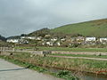 The Seaton valley
 -
 The River Seaton meets the sea
 -
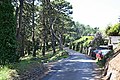 A minor road west of Seaton
 -
 A bilingual road sign in Seaton


Outside links
| ("Wikimedia Commons" has material about Seaton, Cornwall) |