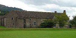
Tretower
| Tretower Welsh: Tretŵr | |
| Brecknockshire | |
|---|---|
 Tretower Court | |
| Location | |
| Location: | 51°52’60"N, 3°10’60"W |
| Data | |
| Post town: | Crickhowell |
| Postcode: | NP8 |
| Dialling code: | 01874 |
| Local Government | |
| Council: | Powys |
| Parliamentary constituency: |
Brecon & Radnorshire |
Tretower is a hamlet in the ancient parish of Llanfihangel Cwmdu in southern Brecknockshire. It lies on the A479 road within the Brecon Beacons National Park at the foot of the Black Mountains just off the Usk Valley.[1] Tretower is frequented by tourists visiting the impressive Tretower Court and the nearby ruins of Tretower Castle, both of which are now managed by Cadw. Cadw own the Court whilst ownership of the Castle lies with the owner of Tyllys Farm in the centre of the village.
Tretower Church in the village is dedicated to St John the Evangelist. Though the site is ancient, the present church was completely re-built in 1876–77 after the earlier structure had fallen into disrepair.[2]
The Green Man Festival takes place annually in the grounds of Glanusk Park a mile to the south-east of the village.
References
- ↑ Ordnance Survey 1:25,000 scale Explorer map OL13 Brecon Beacons National Park: eastern area
- ↑ http://www.cpat.demon.co.uk/projects/longer/churches/brecon/16967.htm
This Brecknockshire article is a stub: help to improve Wikishire by building it up.