Pontymister
| Pontymister | |
| Monmouthshire | |
|---|---|
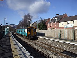
 Risca and Pontymister station | |
| Location | |
| Grid reference: | Expression error: Unexpected < operator.&y=Expression error: Unexpected < operator.&z=120 ST238218964 |
| Location: | 51°36’0"N, 3°6’0"W |
| Data | |
| Post town: | Newport |
| Postcode: | NP11 |
| Dialling code: | 01633 |
| Local Government | |
| Council: | Caerphilly |
| Parliamentary constituency: |
Islwyn |
Pontymister is a village that forms a suburb of its neighbour, the town of Risca, which itself forms part of the conurbation around Newport, Monmouthshire.
History
Originally a farm called Tŷ Isaf, the village came about as a need for housing for the local steel mill and chemical works workforces. Most houses were built in 1920 - 1925.
From the late 1800s there were a number of heavy industries, (steel and chemical), based alongside the river Ebbw. The name Pontymister is said to have come about as the staff were paid from an office built alongside the bridge that connected Ty Isaf to Ochrwyth. The bridge became known as the master's bridge, Pont Y Mister.
Pontymister steel works was famous for being the grave yard for steam trains. Many were brought there in the early 1960s for their scrap value. Some were saved and moved onto Barry Docks.
Amenities
Many local pubs still bear the names of steel making; the Rolling Mill, the Forge and Hammer, etc. Although the Forge hammer became an Indian restaurant - The Tamarind - in 2009.
The Cistercian Way waymarked long-distance footpath passes through Pontymister.
The village is served by Risca and Pontymister railway station.
Outside links
- 'Development of Pontymister' on Risca Museum's website
- Old photos of Pontymister
- Pontymister and surrounding area on geograph.co.uk

This Monmouthshire article is a stub: help to improve Wikishire by building it up.