Seathwaite, Cumberland
| Seathwaite | |
| Cumberland | |
|---|---|
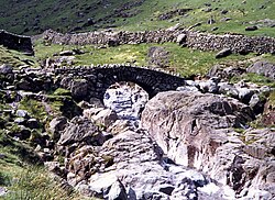
 Stockley Bridge, Seathwaite | |
| Location | |
| Location: | 54°29’48"N, 3°11’0"W |
| Data | |
| Local Government | |
| Council: | Cumberland |
| Parliamentary constituency: |
Workington |
Seathwaite is a hamlet in the Borrowdale valley in Cumberland. It is found 8 miles southwest of Keswick at the end of a minor road that heads south from the portion of the B5289 road that runs between Borrowdale parish and Seatoller over the Honister Pass.[1]
The nearby Seathwaite Fell takes its name from the hamlet and lies about a mile to the south–southwest of it.
The village's name is belived to derive from the Old Norse words sef þveit ("sedges clearing"), as is the nearby village of the same name in Dunnerdale; Seathwaite, Lancashire. [2] The name, then spelled Seuthwayt, first appeared in written records dating from 1340. [3]
History
Along the nearby Newhouse Gill that descends from Grey Knotts is a graphite mine[4][5] that was started after the discovery of graphite there in 1555.[6] The extracted graphite was eventually used to supply the Derwent Cumberland Pencil Company factory in Keswick.
The commercial mining of the unusual solid form of graphite found near Seathwaite hamlet was stopped by about 1891 when veins of the solid graphite became harder to find.[7] Also, around that time the Keswick pencil factories had switched to making pencil pigments out of the familiar combination of clay powder and graphite powder. Graphite powder could be mined and imported from elsewhere.[7] The mine entrance is north–northwest of the hamlet.[4][5]
For many years Seathwaite was a secluded spot being connected to the main road at Seatoller by a rough track. However, as fellwalking became a popular outdoor activity at the end of the 19th century, the hamlet became a popular starting point for walkers bound for the surrounding mountains. The road was eventually surfaced, and now motorists park their cars along the verges on the approach to the farm. Seathwaite has become one of the most popular starting points for walking in the UK giving access to well known mountains such as Scafell Pike, Great Gable and Glaramara.
Famed Lakeland walker Alfred Wainwright made this comment:
Seathwaite, once in a little world of its own with few visitors, has become a pedestrian metropolis. Great days on the fells begin and end here.[8]
Weather

Seathwaite is the wettest inhabited place in England and receives around 140 inches of rain a year.[1][9] In September 1966, five inches of rain fell on Seathwaite and the surrounding fells in an hour, the resulting flood severely damaging the nearby Stockley Bridge, which lies 1,200 yards south of the hamlet. Stockley Bridge is an ancient packhorse bridge which lies on the old route between Borrowdale and the Cumbrian coast. The bridge was widened in 1887 and had to be repaired after the 1966 storm.[10] On 19–20 November 2009 Seathwaite received 12.38 inches of rain in a 24-hour period, a major contributor to the floods of that year. If confirmed this is a record for the amount of rain falling in any place in the United Kingdom within 24 hours.[11][12]
Notes and references
- ↑ 1.0 1.1 The nearby Sty Head Tarn receives as much and more, but without inhabitants to feel it.Ann Bowker. "Seathwaite (Borrowdale) Cumbria the Lake District.". Archived from the original on 2008-04-09. http://web.archive.org/web/20080409095107/http://www.thecumbriadirectory.com/Town_or_Village/Seathwaite_(Borrowdale)/Seathwaite_(Borrowdale).php. Retrieved 2008-05-24.
- ↑ Stuart Rae (cites book by Robert Gambles). "Lake District Walks and Photos". http://web.ukonline.co.uk/sw.rae/. Retrieved 2008-05-30.
- ↑ Gambles, Robert (1985). Lake District Place-names (2 ed.). Yorkshire: Dalesman. pp. 64. ISBN 085206814X.
- ↑ 4.0 4.1 Martin and Jean Norgate, Geography Department, Portsmouth University (2008). "Old Cumbria Gazetteer, black lead mine, Seathwaite". http://www.geog.port.ac.uk/webmap/thelakes/html/lgaz/lk00976.htm. Retrieved 2008-05-19.
- ↑ 5.0 5.1 Alfred Wainwright (2005). A Pictorial Guide to the Lakeland Fells, Western Fells. ISBN 0-7112-2460-9.
- ↑ Ann Bowker, Julian Thurgood, and Dave Newton. "Borrowdale Cumbria and the Lake District.". Archived from the original on 2008-03-21. http://web.archive.org/web/20080321184807/http://www.thecumbriadirectory.com/Cumbria_Countryside/Dales/Borrowdale/Borrowdale.php. Retrieved 2008-05-24.
- ↑ 7.0 7.1 "Industries of Cumbria - Wad". http://www.cumbria-industries.org.uk/wad.htm. Retrieved 2008-05-24.
- ↑ "Wainwright in the Valleys of Lakeland", Alfred Wainwright, ISBN 0 7181 3481 8 Page 192 Gives information on fellwalking and quote from Wainwright.
- ↑ "Lake District National Park Authority - Facts and figures". http://www.lake-district.gov.uk/index/understanding/facts_and_figures.htm. Retrieved 2008-05-24.
- ↑ www.waymarking.com Gives details of Stockley Bridge.
- ↑ Met Office (20 November 2009). "Recent heavy rain over north-west Britain". News Archive. Met Office. http://www.metoffice.gov.uk/corporate/pressoffice/2009/pr20091120.html. Retrieved 21 November 2009.
- ↑ Environment Agency (20 November 2009). "Environment chiefs visit flood-hit Cumbria". News, November 2009. Environment Agency. http://www.environment-agency.gov.uk/news/113477.aspx?. Retrieved 21 November 2009.