Hadstock
| Hadstock | |
| Essex | |
|---|---|
 Hadstock | |
| Location | |
| Grid reference: | TL558448 |
| Location: | 52°4’48"N, -0°16’19"E |
| Data | |
| Population: | 320 (2001) |
| Post town: | Cambridge |
| Postcode: | CB21 |
| Dialling code: | 01223 |
| Local Government | |
| Council: | Uttlesford |
| Parliamentary constituency: |
Saffron Walden |
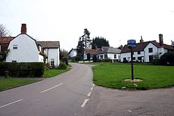
Hadstock is a village in Essex, sitting 6 miles from Saffron Walden, close by the county boundary with Cambridgeshire and about 9 miles from Cambridge. The 2001 recorded a parish population of 320.
On the outskirts of the village is a disused airfield, laid out on the flattened top of a hill. It was used in Second World War. While the official name for the airfield became RAF Little Walden, it was originally named after the village of Hadstock.
Parish church

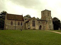
The parish church of St Botolph, named after the local saint, Botwulf of Thorney, has the oldest door still in use in Great Britain. The oldest parts of the church are thought to date from about AD 1020. Since that time the church has received many additions and undergone several renovations.
Big Society
Hadstock has a silver band, the Hadstock Silver Band.

Outside links
| ("Wikimedia Commons" has material about Hadstock) |
