Palestine
| Palestine | |
| Hampshire | |
|---|---|
 Palestine, Hampshire | |
| Location | |
| Grid reference: | SU265405 |
| Location: | 51°9’58"N, 1°37’48"W |
| Data | |
| Population: | 200 (est.) |
| Local Government | |
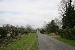
Palestine is a hamlet in Hampshire, in the civil parish of Over Wallop, approximately 6 miles southwest of Andover. It lies very close to the Wiltshire border.
The hamlet consists mainly of fields, farms and a few dozen houses, with about 200 residents in all, most of the houses built as bungalows. The ancient Roman road known as the Portway passes to the north. A more modern route, the main railway line between Salisbury and Andover passes by; there is a station here, named Grateley Station.
It is thought that the name 'Palestine' signifies its remoteness, halfway between Salisbury and Andover.
About the village
The main roads are Streetway Road and the appropriately named Mount Hermon Road and Mount Carmel Road. Recent housing developments have encroached into farming land.
Palestine adjoins the village of Grateley, which has a railway station with hourly trains to London Waterloo.
There is currently a local campaign to establish a separate civil parish for Palestine, including some parts of Grateley parish. Currently, the parish boundary runs down the centre of Streetway Road, meaning that when a new housing development was built on the north side of the road, the residents on the south side could not officially object, as the development was within a different parish.[1]
Outside links
| ("Wikimedia Commons" has material about Palestine) |
- Palestine – UK Villages
References
- ↑ "Minutes of Parish Council Meeting - 12 December 2011". Over Wallop Parish Council. pp. 3–4. http://www.thewallops.net/ParishCouncils/OWpcminutes/11/OWPCDec11.pdf.
