Brecon
| Brecon Welsh: Aberhonddu | |
| Brecknockshire | |
|---|---|
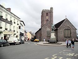
 Brecon, with St. Mary's Church | |
| Location | |
| Grid reference: | SO045285 |
| Location: | 51°56’48"N, 3°23’27"W |
| Data | |
| Population: | 7,901 (2001) |
| Post town: | Brecon |
| Postcode: | LD3 |
| Dialling code: | 01874 |
| Local Government | |
| Council: | Powys |
| Parliamentary constituency: |
Brecon & Radnorshire |
Brecon is a long-established market town in Brecknockshire, of which it is the county town. It is also a military town, playing host to barracks and an army training school, with training facilities nearby and in the mountains.
Brecon lies amongst the mountains and is a centre for hiking.
Today Brecon is a thriving community and is popular as a holiday destination, being on the northern edge of the Brecon Beacons National Park, affording among the best views of the Brecon Beacons themselves, a range of hills, including Pen-y-Fan, the highest point in southern Britain at 2,907 feet.
In August each year is the Brecon Jazz Festival. Concerts are held in both open air and indoor venues, including the town's market hall and the recently opened 400-seat Theatr Brycheiniog.
Military town
The east end of town also has two military establishments:
- Dering Lines, home to the Infantry Battle School (formerly Infantry Training Centre Wales),[1] where infantry officers and other ranks are trained.
- The Barracks, home to the 160th (Wales) Brigade.
- Gurkha Regiments are also based here.
Eight miles to the west of Brecon is Sennybridge Training Area, an important training facility for the Army.[2]
Around and about the town
Cattle market
The west end of Brecon has a small industrial area, and recent years have seen the cattle market moved from the centre of the town to this area, with markets held several times a week.
Monmouthshire and Brecon Canals

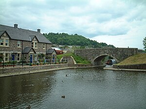
The Brecknock and Abergavenny canal runs for 35 miles between Brecon and Pontymoile, Monmouthshire. There it becomes the Monmouthshire canal and continues to Newport. The towing path is the line of communication; the canal is disjointed by obstructions and road crossings. The canal was built between 1797 and 1812 to link Brecon with Newport and the Severn Estuary.
The canal in Brecon was redeveloped in the 1990s and is now the site of two mooring basins and the Theatr Brycheiniog.
Former railways
The Neath and Brecon Railway reached Brecon in 1867, terminating at Free Street. By this point, Brecon already had two other railway stations:
- Watton - from 1 May 1863 when the Brecon and Merthyr Railway to Merthyr Tydfil was opened for traffic
- Mount Street - in September 1864, with Llanidloes by the Mid Wales Railway which linked to the Midland Railway at Talyllyn Junction. The three companies consolidated their stations at a newly rebuilt Free Street Joint Station from 1871.[3]
Through services from the Midlands ceased in 1930, while services to Neath ended in October, 1962.
History
Early history
In Roman Britain, Y Gaer, Brecon (Cicucium) was established as a Roman cavalry base for the conquest of the west, and Brecon was first established as a military base.
After the Dark Ages, the original Welsh name of the kingdom in whose territory Brecon stands was (in modern orthography) "Brycheiniog", which later became Anglicised to Brecknock, and probably derives from the personal name of the Irish Brychan, the eponymous founder of the kingdom. The English name of Brecon town may also be derived from the same source. First use of the name in English is in the Anglo-Saxon Chronicle for a 916, referring to a battle at "Brecenanmere" (possibly Llangorse Lake).[4]
The Welsh name, Aberhonddu, means "mouth of the Honddu", from the River Honddu, which meets the River Usk near the town centre, a short distance away from the River Tarrell which enters the Usk a few hundred yards upstream.
Before the building of the bridge over the Usk, Brecon was one of the few places where the river could be forded.
Coming of the Normans
The meeting of the Honddu and the Usk was a valuable defensive position for the Norman castle [5] which overlooks the town, built by Bernard de Neufmarche in the late 11th century.[6]
Priory and cathedral
Less than a mile from the castle stands Brecon Cathedral, a modest building compared to many cathedrals. The role of cathedral is a fairly recent one, and was bestowed upon the church in 1923 with the formation of the Diocese of Swansea and Brecon from what was previously the archdeaconry of Brecon, then a part of the Diocese of St David's.
Points of interest
- Brecon Beacons and National Park Visitor Centre (also known as the Brecon Beacons Mountain Centre)
- Brecon Cathedral, the seat of the Diocese of Swansea and Brecon
- St Mary's Church
- Brecon Jazz Festival
- Brecknock Museum
- South Wales Borderers Museum
- Theatr Brycheiniog (Brecon Theatre)
- Christ College, Brecon
Culture
- Brecon hosted the National Eisteddfod in 1889.
Additional photographs
-
Brecon shopping centre
Bibliography
- Davies, John; Jenkins, Nigel (2008). The Welsh Academy Encyclopaedia of Wales. Cardiff: University of Wales Press. ISBN 9780708319536.
References
- ↑ [1]
- ↑ [http://www.army.mod.uk/5div/organisation/160_wales_brigade/index.htm
- ↑ Victorian Brecon - railway stations
- ↑ þæs ymb .iii. niht sende Æþelflæd fyrde on Wealas 7 abræc Brecenanmere 7 þær genam þæs cinges wif feower 7 ðritiga sume (Abingdon Chronicle: The Mercian Register, 916) "About three days after this Æthelflæd sent an army among the Welsh and broke into Breconsmere and there captured the king's wife and some thirty-four men."
- ↑ Castles of Wales
- ↑ Davies (2008), pg80.
