Little Bedwyn
| Little Bedwyn | |
| Wiltshire | |
|---|---|
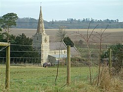
 St Michael's parish church | |
| Location | |
| Grid reference: | SU2966 |
| Location: | 51°23’28"N, 1°34’55"W |
| Data | |
| Population: | 280 (2001) |
| Post town: | Marlborough |
| Postcode: | SN8 |
| Dialling code: | 01672 |
| Local Government | |
| Council: | Wiltshire |
| Parliamentary constituency: |
Devizes |
Little Bedwyn (also spelled Little Bedwin) is a village on the River Dun in Wiltshire, about three miles southwest of the town of Hungerford in neighbouring Berkshire. Great Bedwyn lies a little to the south.
The parish includes the hamlets of Chisbury and Timbridge.
The Kennet and Avon Canal and the Reading to Taunton railway line follow the Dun and pass through the village, and Little Bedwyn is served by Bedwyn railway station, which is about a mile off at Great Bedwyn.
History
Bedwyn Dyke, an early mediæval fortification that may be part of the Wansdyke, passes through the parish.
Most of Little Bedwyn was part of a larger estate called Bedwyn which in the early Middle Ages was held by the Kings of Wessex and of England. Anciently the whole parish was within Savernake Forest.[1]
The National Gazetteer of Great Britain and Ireland of 1868 says of Little Bedwyn:
BEDWIN, (or Bedwyn, Little), a parish and village in the hundred of Kinwardstone, in the county of Wilts, 1 mile to the N.E. of Great Bedwyn. It was anciently a part of Great Bedwyn; but was made a separate parish at the beginning of the 15th century. It is situated on the Kennet and Avon canal, and includes the hamlets of Chisbury and Timbridge. The living is a vicarage in the diocese of Salisbury, of the value of £280, in the patronage of the prebendary. The church, an ancient edifice, partly in the Norman style, is dedicated to St Michael. Chisbury Camp is in this parish. Within the entrenchment are the remains of an old chapel, now converted into a barn. The Wansdyke passes through Little Bedwyn.[2]
The Bedwyn Dyke, an early mediæval fortification that may be a continuation of the Wansdyke, passes through the parish.[3]
About half a mile west of Little Bedwyn is Chisbury Camp, an Iron Age hill fort consisting of earthworks which enclose some 14 acres.[4] Within the camp is the former St Martin's Chapel, a Decorated Gothic building[4] of flint, now a farm building.[5]
In the mid 19th century there was some uncertainty as to whether the parish included about 150 acres of Savernake Forest lying at the parish's western end, but by the 1880s it had been decided that the land was part of the parish.
The population of the parish has fluctuated in recent centuries. Between 1801 and 1871 it rose from 428 to 579, but since then it has fallen gradually and in 2001 stood at 280.[6]
Parish church
The Church of England parish church of St Michael at Little Bedwyn is at the north end of the village, on the bank of the River Dun. It had been built by 1158 and was originally a dependent chapelry of Great Bedwyn.[1] The nave is of three bays.[7] The tower may have been built in the latter part of the 13th century. The chancel and aisles were rebuilt about 1400[1] with Perpendicular Gothic windows.[8] In the 15th century the tower was rebuilt, the spire was added and so was the porch.[1] The north aisle roof dates from about 1500.[1]
In 1841 the nave and chancel were re-roofed.[1] In 1868 the vestry was added and St Michael's was restored under the direction of the Gothic Revival architect T H Wyatt.[1] The spire was dismantled and rebuilt in 1963 after being struck by lightning.[1]
Outside links
References
- ↑ 1.0 1.1 1.2 1.3 1.4 1.5 1.6 1.7 Crowley, 1999, pages 50-69
- ↑ The National Gazetteer of Great Britain and Ireland (1868)
- ↑ Chandler, John (2008). "Little Bedwyn Concise History". Wiltshire County Council. http://www.wiltshire.gov.uk/community/getconcise.php?id=140. Retrieved 2010-03-01.
- ↑ 4.0 4.1 Pevsner & Cherry, 1975, page 174
- ↑ Frank R. Heath, The Little Guides - WILTSHIRE (7th edition, 1949)
- ↑ Population census figures at wiltshire.gov.uk
- ↑ Pevsner & Cherry, 1975, page 296
- ↑ Pevsner & Cherry, 1975, page 297
- Crowley, D.A. (ed.); Baggs, A.P.; Freeman, Jane; Smith, C.; Stevenson, Janet H.; Williamson, E. (1999). A History of the County of Wiltshire: Volume 16: Kinwardstone hundred. Victoria County History. pp. 50–69. http://www.british-history.ac.uk/report.aspx?compid=23038.
- Pevsner, Nikolaus; Cherry, Bridget (revision) (1975) [1963]. Wiltshire. The Buildings of England. Harmondsworth: Penguin Books. pp. 174–175, 296–297. ISBN 0 14 0710.26 4.