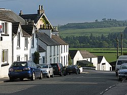
St John's Town of Dalry
| St John's Town of Dalry | |
| Kirkcudbrightshire | |
|---|---|

| |
| Location | |
| Grid reference: | NX618812 |
| Location: | 55°6’22"N, 4°9’54"W |
| Data | |
| Postcode: | DG7 |
| Local Government | |
| Council: | Dumfries and Galloway |
| Parliamentary constituency: |
Dumfries and Galloway |
St John's Town of Dalry, usually referred to simply as Dalry, is a village in Kirkcudbrightshire, historically in the parish of Dalry, from which it takes its name.
It is located sixteen miles from Castle Douglas along the A713 road, and is at the southern terminus of the A702 road toward Edinburgh.
St John's Town of Dalry was named after the Knights of St John (the Knights Hospitaller),[1] and is foud on an old pilgrimage route to Whithorn in Wigtownshire and to St Ninian's Cave at Glasserton.
The town is sited on a bend of the Water of Ken, about three miles (5 km) from the northern edge of Loch Ken.

St. Johns Town makes a good base for exploring the surrounding region, the Southern Upland Way, and the nearby Galloway Hills, including the peaks of Corserine and Cairnsmore of Carsphairn.
The town was the centre of the 1666 Pentland Rising [2][3]
Outside links
| ("Wikimedia Commons" has material about St John's Town of Dalry) |
- Information on Hill Walking in the Galloway Hills
- Rock and Ice climbing in the Galloway Hills
- The Glenkens
References
- ↑ http://www.scottish-places.info/towns/townfirst
- ↑ Jack Hunter, The Upper Glenkens. Stenlake Publishing 2001
- ↑ The history of Galloway. http://archive.org/stream/historyofgallowa02mack#page/n174/mode/1up
