Wyddial
| Wyddial | |
| Hertfordshire | |
|---|---|
 St Giles, Wyddial | |
| Location | |
| Grid reference: | TL375315 |
| Location: | 51°57’54"N, -0°0’0"E |
| Data | |
| Postcode: | SG9 |
| Local Government | |
| Council: | East Hertfordshire |
Wyddial is a village in Hertfordshire, near Buntingford. The Greenwich Meridian runs through the village.
The name of the village is first attested in the Domesday Book of 1086 and means 'willow nook'.[1]
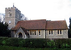
The parish church of St Giles dates from the 14th century when the nave was built. The tower and chancel date from the 15th century. In 1859 the nave was restored and the chancel and south porch rebuilt by Baillie & Co.[2]

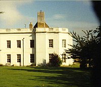
Wyddial Hall is a Grade II listed building, which was originally built in the early 16th century. The hall is situated just north of the church and has access via the churchyard. In 1733 it was remodelled after a damaging fire for Francis Goulston. By 1780 it had been acquired by John Thomas Ellis, MP for Lostwithiel, who made alterations, and later changes were made by Charles Heaton-Ellis.[3] Admiral Edward Heaton-Ellis, who fought in the Battle of Jutland, was born at Wyddial.
References
- ↑ Eilert Ekwall, Concise Oxford Dictionary of English Place-names, p.540.
- ↑ British Listed Building - Church of St Giles Wyddial
- ↑ British Listed Buildings - Wyddial Hall
Outside links
| ("Wikimedia Commons" has material about Wyddial) |
