Wormley, Hertfordshire
| Wormley | |
| Hertfordshire | |
|---|---|
| Location | |
| Grid reference: | TL364056 |
| Location: | 51°43’57"N, 0°1’31"W |
| Data | |
| Post town: | Broxbourne |
| Postcode: | EN10 |
| Dialling code: | 01992 |
| Local Government | |
| Council: | Broxbourne |
| Parliamentary constituency: |
Broxbourne |
Wormley is a village in south-eastern Hertfordshire, of which the main village is found to the east of the dual carriageway of the A10 Great Cambridge Road, sandwiched between Broxbourne and Turnford in the conurbated towns of that here stretch along the Lea Valley. Wormley has the New River as its western boundary and to the east is the River Lea. The high road has a goodly number of shops.
Wormley had a population of 8,146 recorded at the 2001 census. The nearest rail station is Broxbourne which is a commuter town to London.
West of the A10 the countryside spreads out gently, and here are found rather different landscape bearing the name of Wormley; the farmstead of Wormleybury and beyond it Wormley West End, and further west is Wormley Wood. These have escaped the suburbanisation.
Wormley has Wormley playing fields where Wormley Rovers Football Club and Wormley Cricket Club are based. Wormley also has 'Top Field and Cozens Grove Local Nature Reserve'. [1]
Church
St Lawrence's Church' forms part of the Parish of Broxbourne with Wormley and is a member of the New River Group Ministry.[2] Wormley Church of England Primary School was founded in 1864 and had 358 pupils in 2009.[3]

St Lawrence has a nave and font dating from the 12th century. There are several brasses from the 15th century and a marble monument to the Purvy family dated 1617.[4]
Wormley West End
Wormley West End is a couple of miles west of the main village, a hamlet in the open country. It is amidst the woodlands: Wormley Wood to the west, Thunderfield Grove to the south and Cowheath Wood to the north.
Paradise Wildlife park is in Cowheath Wood.
History
Wormley was one of the manors which were granted by Harold Godwinson to the canons of Waltham Holy Cross. Wormley remained under the control of the monastery until its dissolution in 1540 when it was granted to Sir Edward North.[5]
The manor house, Wormleybury on the south side of Church Lane, was totally rebuilt in 1734 and remodelled in 1767 and 1782 by Robert Mylne for Sir Abraham Hume. It has a stone portico and steps, with an octagonal bell turret. There is interior decoration of 1779 by Robert Adam. It is a Grade I Listed building.[6]

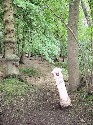
There are two Coal-tax posts in Wormley and both are in unusual locations. One is in the middle of Wormley Wood and the other on the north side of a country lane at a point where it is hard to imagine any significant trade traffic passing by.[7] They were erected following the London Coal and Wine Duties Continuance Act 1861.
Outside links
| ("Wikimedia Commons" has material about Wormley, Hertfordshire) |
References
- ↑ http://www.oss.org.uk/wormley-nature-reserve-saved/
- ↑ http://www.broxbournewithwormley.org.uk/
- ↑ http://www.ofsted.gov.uk/filedownloading/?id=928035&type=1&refer=0
- ↑ History of the County of Hertford pp. 489-490
- ↑ [A History of the County of Hertford: Volume 3 (1912)] (pp. 487-8)
- ↑ http://www.britishlistedbuildings.co.uk/en-157391-wormleybury-hoddesdon
- ↑ Bawtree, M. (1969) The City of London Coal Duties, printed in the London Archaeologist
