Taplow
| Taplow | |
| Buckinghamshire | |
|---|---|
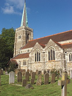
 St Nicholas, Taplow | |
| Location | |
| Grid reference: | SU910822 |
| Location: | 51°31’53"N, -0°41’14"W |
| Data | |
| Population: | 1,584 (2001) |
| Post town: | Maidenhead |
| Postcode: | SL6 |
| Dialling code: | 01628 |
| Local Government | |
| Council: | Buckinghamshire |
| Parliamentary constituency: |
Beaconsfield |
Taplow is a prosperous village in Buckinghamshire. It stands in the very south of the county, on the north bank of the River Thames facing Maidenhead on the opposite bank in Berkshire.
The village name is Old English in origin, and means 'Tæppa's hill'; the Anglo-Saxon burial mound of Taeppa can still be visited. Taplow was recorded in the Domesday Book of 1086 as Thapeslau.
Taplow Court nearby is also the site of an early Iron Age hill fort.[1][2]
William Grenfell, 1st Baron Desborough lived at Taplow Court.[3] Nearby is Cliveden, former home of Nancy Astor.
Outside links
| ("Wikimedia Commons" has material about Taplow) |
References
- ↑ Bucks Archeological Service Historic Environment Resource Assessment
- ↑ Hart, Jonothan; Mc Sloy, E. R. (2011). "A Late Prehistoric Hilltop Settlement and Other Excavations Along the Taplow and Dorney Water Pipeline". Records of Buckinghamshire (Buckinghamshire Archeological Society) 51.
- ↑ Christopher Winn, I Never Knew That About the River Thames (Random House, 2010) ISBN 0-09-193357-9 p.138