Ascott d'Oyley
| Ascott d'Oyley | |
| Oxfordshire | |
|---|---|
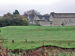
 The castle earthworks, Ascott D'Oyley | |
| Location | |
| Grid reference: | SP304187 |
| Location: | 51°52’0"N, 3°26’27"W |
| Data | |
| Postcode: | OX7 |
| Local Government | |
| Council: | West Oxfordshire |
| Parliamentary constituency: |
Witney |
Ascott d'Oyley forms, with neighbouring Ascott Earl, the combine village of Ascott-under-Wychwood, nestled along the south bank of the River Evenlode in the south-west of Oxfordshire.
The name 'Ascott' is derived from the Old English east cot, meaning 'east cottage', whilst d’Oyley was appended because Wido de Oileo ‘held the place in the late eleventh century.’[1] Ascott d’Oyley with its sister village Ascott Earl together form the larger community of Ascott-under-Wychwood. Ascott d’Oyley is recorded in the 1086 Domesday Book as having 14 households and a mill, under the lordship of Roger d'Oilly, and tenanted by Robert d’Oilly, whose family gives the village its name.[2]
An earthen mound marks the remains of Ascott d’Oyley Castle.
Today the village consists of stone-built houses and cottages grouped around the High Street and Mill Lane. Ascott d'Oyley is served by Windrush Valley School and Ascott-under-Wychwood railway station.
See also
Outside links
| ("Wikimedia Commons" has material about Ascott d'Oyley) |
References
- ↑ Field, John (1980). Place-names of Great Britain and Ireland. Newton Abbot, Devon: David & Charles. p. 26. ISBN 0389201545. OCLC 6964610.
- ↑ d'Oyley Ascott d'Oyley in the Domesday Book
