Yarrow, Selkirkshire
| Yarrow | |
| Selkirkshire, Peeblesshire | |
|---|---|
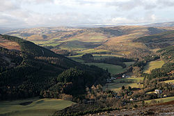
 The Yarrow Valley at Yarrowford | |
| Location | |
| Grid reference: | NT357277 |
| Location: | 55°32’20"N, 3°1’5"W |
| Data | |
| Post town: | Selkirk |
| Postcode: | TD7 |
| Local Government | |
| Council: | Scottish Borders |
| Parliamentary constituency: |
Berwickshire, Roxburgh and Selkirk |
Yarrow is a parish on the borders of Selkirkshire and Peeblesshire, but chiefly of the former. The name "Yarrow" may derive from the Celtic word garw meaning "rough" or possibly share a derivation with the English name "Jarrow".[1][2]
The parish mainly corresponds with the river valley of the Yarrow Water from its source in the west at St Mary's Loch until its passes into the parish of Selkirk between Yarrowford and Broadmeadows, just upstream from Foulshiels.[3][4] It has an area of 48,851 acres.[5]
The civil parish incorporates the district of Megget in Peeblesshire, which previously formed a detached part of Lyne. It is bordered on the west and north by the parishes of Tweedsmuir, Drumelzier, Manor, Peebles and Traquair in Peeblesshire; on the east by Caddonfoot and Selkirk; and on the south by Kirkhope and Ettrick in Selkirkshire. There is also a small border with the parish of Moffat in Dumfriesshire.
St Mary's Loch is the principal loch of southern Scotland, being 3½ miles long and in some places thirty fathoms deep.[4]
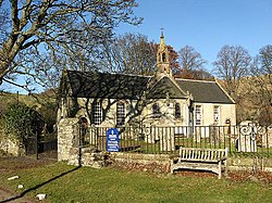
The parish includes the settlements of Yarrow Feus and Yarrowford, as well as Yarrow itself, which is the site of the Kirk, Manse and former school. The Kirk has a central location in the parish and is about 10 miles distant from the furthermost boundaries. [4]
History
In the foundation charter of Selkirk Abbey, granted by King David in the twelfth century, the native name is translated as Garua in Latin, which in later documents mutated into Zarof, Yharrow and Yara, before assuming its present form of Yarrow. [4]

The old name of the parish was St Mary's or, in some records, St Mary of the Lowes, from its vicinity to two considerable lochs (Loch of the Lowes and St Mary’s Loch). In the year 1640, the parish church was moved from the vicinity of St Mary’s Loch to the banks of the Yarrow, which henceforth imparted its name to the parish. [4] This site was adjacent to a pre-reformation chapel at Deuchar.[6] However, the glebe remained on the north side of the loch, the same that was attached to St Mary's Chapel, now eight miles to the west of the kirk to which it belonged. [4] The kirk was renovated in 1826, 1876 and 1906. However its interior was destroyed by fire in 1922, but restored following year. [7]
The area of the parish of Yarrow was formerly one of the most extensive in the south of Scotland, encompassing most of the valley of the Yarrow and a considerable part of that of the Ettrick. The shape was very irregular and, although the population was low (1,264 in 1841), it was difficult for the minister of the parish to reach many of them, both as regards distance and the want of roads and bridges.
To ameliorate this problem, the Duke of Buccleuch in 1851 instigated proceedings to have the southern part, in the Ettrick valley, disjoined from the parish and erected into a separate parish. The duke proposed to make over the chapel at Ettrickbridge, which he had built in 1839, to be the church of the new parish, to erect a suitable manse for the minister, and to bear the expense of the judicial separation proceedings. The new parish would extend to nine miles in length up the river Ettrick, be about six miles wide, with an area of about 50 square miles, population 600. The remaining portion of the parish of Yarrow would contain a population of about 670, extending in length to about 19 miles, and in breadth. The new parish was created and named Kirkhope, an old name for the Ettrickbridge area [8]
Thus the population of Yarrow Parish had reduced from 1,270 to 600 by this separation and it would fall further to 500 in 1901[9] and 402 in 1951.[10]
References
- ↑ Words & places: illustrations of history, ethnology and geography, by Isaac Taylor, publ. Kessinger, 1921, p. 131.
- ↑ History of the Celtic Place-names of Scotland, by W.J. Watson; first published 1926; reprinted 2004 with introduction by Simon Taylor. Edinburgh. Birlinn. ISBN 1-84158-323-5, p. 522. Contains the note "Yarrow is Gierua c. 1120, Gierwa, Gieruua c. 1150 (Lawrie). This, like Gala, is an Anglo-Saxon name and may be compared with Jarrow, in Bede 'In Gyruum'."
- ↑ Ordnance Survey one inch to one mile map, Selkirk sheet, publ. 1961
- ↑ 4.0 4.1 4.2 4.3 4.4 4.5 New Statistical Account of Scotland, Vol III Roxburgh, Peebles, Selkirk, publ.William Blackwood, 1845, pp.29-54 (Selkirkshire section)
- ↑ Survey Gazetteer of the British Isles, by J. Bartholomew, 1905
- ↑ Ordnance Gazetteer of Scotland, by Francis Groome, publ.1896, article on Yarrow
- ↑ Listed buildings in Scotland site http://portal.historic-scotland.gov.uk/designation/LB17128 retrieved Feb 2016
- ↑ Statistical History Of Scotland, by James Hooper Dawson,Edinburgh 1857 (article on Yarrow parish)
- ↑ Survey Gazetteer of the British Isles, by J. Bartholomew, 1905
- ↑ 1951 Census of Great Britain