Blairlogie
| Blairlogie | |
| Stirlingshire | |
|---|---|
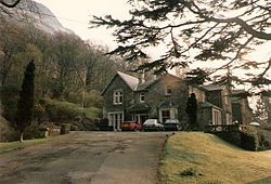
 Blairlogie House, Blairlogie | |
| Location | |
| Grid reference: | NS829968 |
| Location: | 56°8’58"N, 3°53’11"W |
| Data | |
| Post town: | Stirling |
| Postcode: | FK9 |
| Dialling code: | 01259 |
| Local Government | |
| Council: | Stirling |
| Parliamentary constituency: |
Stirling |
Blairlogie is a village in Stirlingshire, just east of Bridge of Allan and standing at the base of the great cliff of Dumyat between Stirling and Menstrie. Blairlogie mainly comprises 17th-19th-century cottages and has been declared a ‘conservation village’.
Between 1598 and 1609, the minister of Logie Parish was the poet Alexander Hume.
The cliff beneath which the village stands is the beginning of the Ochil Hills. Blairlogie is thus the westernmost of the string of village beneath the scarp of the Ochil Hills which are collectively known as the Hillfoots Villages
Outside links

- Streetmap - Blairlogie
- Look Aboot Ye - Clackmannanshire Community News, Information and Forums
- Blairlogie Archive
| The Hillfoots Villages of Stirlingshire, Clackmannanshire and Perthshire |
|---|
|
Blairlogie • Menstrie • Alva • Tillicoultry • Dollar • Pool of Muckhart |