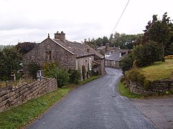
Farleton, Lancashire
| Farleton | |
| Lancashire | |
|---|---|
 Farleton | |
| Location | |
| Grid reference: | SD570663 |
| Location: | 54°5’29"N, 2°39’27"W |
| Data | |
| Postcode: | LA2 |
| Local Government | |
| Council: | Lancaster |
Farleton is a small village in Lancashire, half a mile north-east of Claughton and a mile and a half south-west of Hornby. It stands just off the A683 road to Lancaster, on the south side of the River Lune.
The Toll House in the village is a Grade II listed building.[1] In the 1920s it was a garage.[2]
Outside links
| ("Wikimedia Commons" has material about Hornby-with-Farleton) |
References
- ↑ Toll House, Hornby-with-Farleton - British Listed Buildings
- ↑ First white lines in the World? – Lancashire Council, 2013 (archive)
