Ousby
| Ousby | |
| Cumberland | |
|---|---|
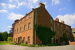
 Melmerby Hall | |
| Location | |
| Grid reference: | NY6234 |
| Location: | 54°42’18"N, 2°34’55"W |
| Data | |
| Population: | 362 (2001) |
| Post town: | Penrith |
| Postcode: | CA10 |
| Dialling code: | 01768 |
| Local Government | |
| Council: | Westmorland & Furness |
| Parliamentary constituency: |
Penrith and The Border |
Ousby is a village in northern Cumberland. The parish had a population of 362 in 2001; the parish includes the larger village of Melmerby to the north and the hamlets of Crewgarth, Row, Shire and Townhead.
The village is about a mile south of the village of Melmerby, near the A686 road. Ousby Fell rises to the east of the village.
Ousby is a Thankful Village, one those few parishes which suffered no casualties during the First World War, and the only such village in the county.
Abiout the village
The parish church is St Lukes, in the Diocese of Carlisle: it is outside the village, beyond Row, up the Ardale Beck. It has recently been restored. The church has two stained glass windows - the three light East window contains an image of St Luke by John Scott of Carlisle, while the other window - in the south east of the nave - 'Pro Patria' - is a memorial to those who fell in World War I, albeit that Ousby, uniquely in Cumberland, was spared any loss.
Another chapel stands in Townhead.
Ousby has a pub called the Fox Inn and a camp site.
Outside links
References

This Cumberland article is a stub: help to improve Wikishire by building it up.