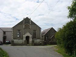
Llanfwrog, Anglesey
| Llanfwrog | |
| Anglesey | |
|---|---|

| |
| Location | |
| Grid reference: | SH301843 |
| Location: | 53°19’31"N, 4°33’7"W |
| Data | |
| Local Government | |
| Council: | Anglesey |
| Parliamentary constituency: |
Ynys Môn |
Llanfwrog is a village on the Isle of Anglesey. It lies about 4 miles to the northeast of Holyhead. The village lies near the coast about a mile east of Beach Gribin. A country road connects it with the A5025 road, one mile east, and Llanfaethlu, approximately 2½ miles to the north.
According to tradition, the village was founded by St Llanfwrog Mwrog. The only other place that is associated with the name of a saint Llanfwrog is Llanfwrog, Denbighshire.
In the Middle Ages Llanfwrog parish lay in the commote Talybolion in the Cemaes Hundred. The church belonged to the rectory of the parish of Llan by the eighteenth century.[1]
References
- ↑ Atlas Môn (Llangefni, 1972), mapiau tt. 38, 76.