Land's End


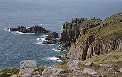
Land's End is a headland bearing a small hamlet in the very west of Cornwall. It is the westernmost point of southern Great Britain and famed as the start of the great journey from Land's End to John o' Groats.
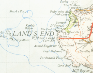
Land's End lies at the end of the Penwith peninsula some eight miles west-southwest of Penzance. The closest village of any size is Sennen
Though the most south-westerly point of mainland Great Britain, it is not the furthest west, an honour belonging to Ardnamurchan Point in Argyll. It is however and the westernmost mainland point in England and Wales.
Just over a mile west of Land's End lie the Longships, a group of rocky islets where the Longships Lighthouse stands. The Isles of Scilly lie some 28 miles southwest of Land's End. In Cornish myth a lost land now rolled beneath the waves of the sea once stretched out between Land's end and the islands, which has been identified with the land of Lyonesse in Arthurian literature.
The journey from Land's End to John o' Groats in Caithness is 838 miles by road and defines the length of races, walks or charitable events.
An early reference to Land's End is found in the Anglo-Saxon Chronicle, where a Cornish version of the name is preserved in the form Penwiþsteort ("Penwith headland").
In 1769 the Antiquarian, William Borlase, summarising mediæval foundation myths, wrote:
"Of this time we are to understand what Edward I. says (Sheringham. p. 129.) that Britain, Wales, and Cornwall, were the portion of Belinus, elder son of Dunwallo, and that that part of the Island, afterwards called England, was divided in three shares, viz. Britain, which reached from the Tweed, Westward, as far as the river Ex; Wales inclosed by the rivers Severn, and Dee; and Cornwall from the river Ex to the Land's-End".
It has been claimed that Land's End is not in fact the westernmost point of mainland Cornwall but that Cape Cornwall a little to the north reaches further west. Close geographical measurement however gives the prize to Land's End. On an Ordnance Survey map, which is aligned to a conventional gridnorth, Land's End is certainly shown the more westerly, but according to a measurement of True North, the very furthest rocky spit of Land's End is only a touch more westerly.
Visitors
In 1987 Peter de Savary bought Land's End. He had two new buildings erected and instigated much of the present theme park development. In 1991 he sold both Land's End and John o' Groats for an undisclosed sum to businessman Graham Ferguson Lacey. The current owners bought Land's End in 1996.
Attractions at the theme park include children's playgrounds and recorded music. Twice a week in August there are firework displays. Nearby is the Land's End Hotel.[1]
The public highway ends long before the headland and in season it is closed except to paying visitors. Nevertheless, the site is freely accessible from the footpath running along the cliffs from Sennan Cove.
Picture gallery
-
Cliffs at Land's End
-
Land's End, the most westerly point in Cornwall
-
The tourist centre at Land's End
-
The tourist centre at Land's End
-
The lighthouse off Land's End
-
Looking south from Land's End
-
Looking west from Land's End
-
Looking north from Land's End
References
- ↑ Clegg, David (2005) Cornwall & the Isles of Scilly; 2nd ed. Leicester: Matador; pp. 123-24


