Warwick-on-Eden
| Warwick-on-Eden | |
| Cumberland | |
|---|---|
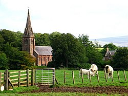
 Warwick-on-Eden, looking towards the church | |
| Location | |
| Grid reference: | NY464565 |
| Location: | 54°54’4"N, 2°50’6"W |
| Data | |
| Post town: | Carlisle |
| Postcode: | CA4 |
| Dialling code: | 01228 |
| Local Government | |
| Council: | Cumberland |
| Parliamentary constituency: |
Carlisle |
Warwick-on-Eden is a small village in Cumberland, standing on the west bank of the River Eden, four miles east of Carlisle and about seven miles south-west of Brampton. The village is on the A69, which crosses the Eden here: on the opposite bank stands Warwick Bridge, which has grown to be larger than its parent village.
The River Irthing joins the Eden just a mile downstream of Warwick-on-Eden
Other nearby villages include Wetheral, Warwick Bridge, Scotby and Aglionby.
Parish church
The parish church was St Leonard's Church, but it closed for worship when the ecclesiastical parish merged with that of Wetheral on 30 April 2017,[1] to become the parish of “Wetheral with Warwick”.
St Paul's Holme Eden, the church in Warwick Bridge, remains open, if within a united benefice with Wetheral.
Outside links
| ("Wikimedia Commons" has material about Warwick-on-Eden) |
References
- ↑ St Leonard, Warwick on ‘A Church Near You’
