Bulford
| Bulford | |
| Wiltshire | |
|---|---|
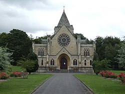
 Garrison Church of St George, Bulford Camp | |
| Location | |
| Grid reference: | SU155445 |
| Location: | 51°12’54"N, 1°46’19"W |
| Data | |
| Population: | 4,698 (2001) |
| Post town: | Salisbury |
| Postcode: | SP4 |
| Dialling code: | 01980 |
| Local Government | |
| Council: | Wiltshire |
| Parliamentary constituency: |
Devizes |
Bulford is a village in Wiltshire, at the meeting of the Nine Mile River with the River Avon, close to Salisbury Plain. According to the 2001 census the parish had a population of 4,698.
The name 'Bulford' is from the English bulut ieg ford meaning 'ragged robin island ford'.[1] It is recorded in the Wiltshire Charter Rolls of 1199 as Bultiford and as Bultesforda in 1270. It is then recorded as Bulteforde in the Ecclesiastical Tax Records of 1291.[2]
About the village
The village is separated from the site of Bulford Camp, an army base, and is close to Durrington, Amesbury and Larkhill.
Avondale School in the village is a private preparatory school which educates, amongst others, some of the children from the army camp.

Bulford is perhaps most famous for being the site of the Bulford Kiwi a large chalk figure, depicting a kiwi, on the hill above the village.
Outside links
| ("Wikimedia Commons" has material about Bulford) |
References
- ↑ "Bulford, Wiltshire". Key to English Placenames. University of Nottingham. http://kepn.nottingham.ac.uk/map/place/Wiltshire/Bulford. Retrieved July 29, 2012.
- ↑ "Bulford". Surname Database. http://www.surnamedb.com/Surname/Bulford. Retrieved July 29, 2012.
