Partington
| Partington | |
| Cheshire | |
|---|---|
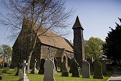
 St Mary's Church, Partington | |
| Location | |
| Grid reference: | SJ715915 |
| Location: | 53°25’12"N, 2°25’48"W |
| Data | |
| Population: | 7,327 (2001) |
| Post town: | Manchester |
| Postcode: | M31 |
| Dialling code: | 0161 |
| Local Government | |
| Council: | Trafford |
| Parliamentary constituency: |
Stretford and Urmston |
Partington is a town in Cheshire about 10 miles to the southwest of Manchester city centre, into whose conurbation it has become drawn. It stands on the southern bank of the Manchester Ship Canal, opposite Cadishead on the northern bank. It had a population of 7,327 recorded in 2001.
A paper mill built in Partington more than 250 years ago was the first factory in the area. The completion of the Manchester Ship Canal in 1894 transformed Partington into a major coal-exporting port and attracted a range of other industries. Until 2007 Shell Chemicals UK operated a major petrochemicals manufacturing complex in Carrington, Partington's closest neighbour, to the east. The gas storage facility in the north-eastern corner of the town was once a gasworks and another significant employer.
Shortly after the Second World War, local authorities made an effort to rehouse people away from Victorian slums in inner-city Manchester. An area of Partington extended as an overspill estate is now one of the most deprived parts of the Greater Manchester conurbation. The Cheshire Lines Committee opened a railway line through the town in 1873, but it closed in 1964.
The main shopping area of Partington is on Central Road, in the centre of town. Partington also has its own traditional market on Smithy Lane.
Name
The name of Partington is from Old English but uncertain in origin: the first element may be a personal name such as Pearta or Pærta, or part (partitioned land), whole the suffix inga means "sons of" or "people of" (gen. pl.), so "Pearta's clan's village".
History
Partington, first recorded in 1260,[1] was in the mediæval and post-mediæval parish of Bowdon.[2] The village consisted of dispersed farmsteads, with no nucleated centre. It was surrounded by wetlands on all sides, reducing the amount of land available for agriculture.[3] According to the hearth tax returns of 1664, Partington had a population of 99.[4]

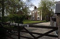
In 1755 a paper mill opened in Partington, on the River Mersey, and became the first factory established in the area.[5] Erlam Farmhouse dates from the late 18th century and is a Grade II listed building.[6]
Also protected as a Grade II listed building are the stocks on the village green, which are regreatbly no longer used for the village's malefactors. Its stone pillars are from the 18th century, although the wooden restraints were replaced in the 20th century.[7]
The completion of the Manchester Ship Canal in 1894 transformed Partington into a major coal-exporting port. The canal was widened to 250 feet for three-quarters of a mile to allow for the construction of a coaling basin, equipped with four hydraulic coal hoists. Partington was the nearest port to the Lancashire Coalfields, and brought the Yorkshire collieries 30 miles closer to the sea. Between 1898 and 1911, exports of coal accounted for 53.4% of the total export tonnage carried by the ship canal. The coal trade in turn resulted in Partington's becoming a major railway depot, and attracted a range of other industries, including the Partington Steel & Iron Company, which was encouraged by the availability of coal to construct a steelworks. The works became a part of the Lancashire Steel Corporation in 1930, and dominated the economy of nearby Irlam until their closure in 1976.[8]
After the Second World War, Partington was extended as an overspill estate.[9]

Outside links
| ("Wikimedia Commons" has material about Partington) |
References
- ↑ Nevell (1997), p. 32.
- ↑ Nevell (1997), p. 27.
- ↑ Nevell (1997), p. 45
- ↑ Nevell (1997), p. 59.
- ↑ Nevell (1997), p. 89.
- ↑ Images of England — details from listed building database (212961) Erlam Farmhouse, Bailey Lane
- ↑ Images of England — details from listed building database (212962) Stocks, Partington
- ↑ Farnie (1980), p. 98.
- ↑ Nicholas Timmins (26 June 1995). "Two Labour councils set to relinquish housing". The Independent. http://www.independent.co.uk/news/two-labour-councils-set-to-relinquish-housing-1588344.html. Retrieved 20 April 2009.
- Farnie, D. A. (1980). The Manchester Ship Canal and the rise of the Port of Manchester. Manchester University Press. ISBN 0-7190-0795-X.
- Nevell, Mike (1997). The Archaeology of Trafford. Trafford Metropolitan Borough with the University of Manchester Archaeological Unit. ISBN 1-870695-25-9.
- Nicholls, Robert (2004). Curiosities of Greater Manchester. Sutton Publishing. ISBN 0-7509-3661-4.
- Warburton, Norman (1970). Warburton: The Village and the Family. Research Publishing Company. ISBN 0-7050-0007-9.
