Scoberry Footbridge: Difference between revisions
Jump to navigation
Jump to search
Created page with "{{Infobox bridge |name=Scoberry Footbridge |county 1=Durham |county 2=Yorkshire |picture=Scoberry Bridge - geograph.org.uk - 2109675.jpg |picture caption=Scoberry Bridge |os g..." |
No edit summary |
||
| Line 25: | Line 25: | ||
A bridge crossed the river here, but was damaged in the floods of 1942 and was closed until repairs were completed. It was replaced in 1971. | A bridge crossed the river here, but was damaged in the floods of 1942 and was closed until repairs were completed. It was replaced in 1971. | ||
The nearest hamlet is [[Bowlees]] on the Durham bank, where there is a visitor centre for those visiting [[High Force]] and [[Low Force]] upriver. Nearby is [[Newbiggin, | The nearest hamlet is [[Bowlees]] on the Durham bank, where there is a visitor centre for those visiting [[High Force]] and [[Low Force]] upriver. Nearby is [[Newbiggin, Teesdale|Newbiggin]]. | ||
==References== | ==References== | ||
Latest revision as of 21:15, 1 September 2024
| Scoberry Footbridge | |
| County Durham, Yorkshire | |
|---|---|
 Scoberry Bridge | |
| Location | |
| Carrying: | Footpath |
| Crossing: | River Tees |
| Location | |
| Grid reference: | NY91032735 |
| Location: | 54°38’28"N, 2°8’26"W |
| Structure | |
| History | |
| Built 1971 | |
| Information | |
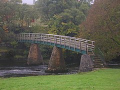
The Scoberry Footbridge crosses the River Tees between County Durham on the north bank and the North Riding of Yorkshire to the south.
A bridge crossed the river here, but was damaged in the floods of 1942 and was closed until repairs were completed. It was replaced in 1971.
The nearest hamlet is Bowlees on the Durham bank, where there is a visitor centre for those visiting High Force and Low Force upriver. Nearby is Newbiggin.
References
- Scoberry Footbridge: Bridges on the Tyne
| Bridges and crossings on the River Tees | ||||||
|---|---|---|---|---|---|---|
| Cronkley Bridge | Holwick Head Footbridge | Wynch Bridge | Scoberry Footbridge | Middleton Bridge | Beckstones Wath Footbridge | Eggleston Bridge |