Moor House Bridge: Difference between revisions
Jump to navigation
Jump to search
Created page with "{{Infobox bridge |name=Moor House Bridge |county 1=Westmorland |county 2=Yorkshire |picture=Bridge over the R Tees close to Troutbeck Foot (geograph 7376397).jpg |picture capt..." |
No edit summary |
||
| Line 1: | Line 1: | ||
{{Infobox bridge | {{Infobox bridge | ||
|name=Moor House Bridge | |name=Moor House Bridge | ||
|county 1= | |county 1=Cumberland | ||
|county 2= | |county 2=Westmorland | ||
|picture=Bridge over the R Tees close to Troutbeck Foot (geograph 7376397).jpg | |picture=Bridge over the R Tees close to Troutbeck Foot (geograph 7376397).jpg | ||
|picture caption=Moor House Bridge | |picture caption=Moor House Bridge | ||
| Line 21: | Line 21: | ||
|website= | |website= | ||
}} | }} | ||
'''Moor House Bridge''' is a small footbridge on the infant [[River Tees]], close to the river's source on [[Cross Fell]], high in the [[Pennines]]. The Tees here marks the border in the fells between [[ | '''Moor House Bridge''' is a small footbridge on the infant [[River Tees]], close to the river's source on [[Cross Fell]], high in the [[Pennines]]. The Tees here marks the border in the fells between [[Cumberland]] and [[Westmorland]], and so the bridge joins these two counties. | ||
This is the first bridge on the Tees, just four miles from its source. It is close to the ridge of the Pennines at the watershed between east and west. The path that crosses the bridge is part of the 'River Tyne Trail'. | This is the first bridge on the Tees, just four miles from its source. It is close to the ridge of the Pennines at the watershed between east and west. The path that crosses the bridge is part of the 'River Tyne Trail'. The bridge stands just above where the [[Trout Beck]] joins the Tees. A mile below the bridge the Crook Burn joins the stream, where Cumberland, Westmorland and [[County Durham]] meet. | ||
The bridge was strengthened in 1967 and the timber deck replaced in 1993. | The bridge was strengthened in 1967 and the timber deck replaced in 1993. | ||
Latest revision as of 22:13, 30 August 2024
| Moor House Bridge | |
| Cumberland, Westmorland | |
|---|---|
 Moor House Bridge | |
| Location | |
| Type: | Concrete beam |
| Carrying: | Footpath |
| Crossing: | River Tees |
| Location | |
| Grid reference: | NY76063386 |
| Location: | 54°41’57"N, 2°22’23"W |
| Structure | |
| Type: | Concrete beam |
| History | |
| Information | |
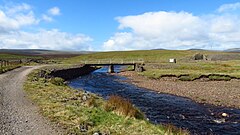
Moor House Bridge is a small footbridge on the infant River Tees, close to the river's source on Cross Fell, high in the Pennines. The Tees here marks the border in the fells between Cumberland and Westmorland, and so the bridge joins these two counties.
This is the first bridge on the Tees, just four miles from its source. It is close to the ridge of the Pennines at the watershed between east and west. The path that crosses the bridge is part of the 'River Tyne Trail'. The bridge stands just above where the Trout Beck joins the Tees. A mile below the bridge the Crook Burn joins the stream, where Cumberland, Westmorland and County Durham meet.
The bridge was strengthened in 1967 and the timber deck replaced in 1993.
| ("Wikimedia Commons" has material about Moor House Bridge) |
References
- Moor House Bridge: Bridges on the Tyne
| Bridges and crossings on the River Tees | ||||||
|---|---|---|---|---|---|---|
| Source | Moor House Bridge | Birkdale Footbridge | Cronkley Bridge | Holwick Head Footbridge | Wynch Bridge | Scoberry Footbridge |
