Difference between revisions of "Coolgreany"
From Wikishire
(Created page with "{{Infobox town |name=Coolgreany |irish=Cúil Ghréine |county=Wexford |picture=The Coolgreany Inn - geograph.org.uk - 705813 (cropped).jpg |picture caption=Coolgreany village...") |
(No difference)
|
Latest revision as of 20:01, 29 May 2024
| Coolgreany Irish: Cúil Ghréine | |
| County Wexford | |
|---|---|
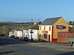
 Coolgreany village | |
| Location | |
| Grid reference: | T181683 |
| Location: | 52°45’54"N, 6°14’2"W |
| Data | |
| Population: | 376 (2016) |
| Local Government | |
Coolgreany is a village located in north County Wexford, in the shadow of Croghan Mountain, overlooking Tara Hill in the extreme north of County Wexford.
The name of this place is form the Irish Cúil Ghréine, meaning 'Nook of the sun'.[1][2]
The village is two miles from the N11 Dublin-Wexford road, which passes by at Inch, County Wexford|Inch. It has a Gaelic Athletic Association pitch, handball alley, a grocery store, two pubs and a primary school, which latter opened in the early 1980s.
Nearby major towns are Arklow and Gorey.
Historically the village is known for the evictions of 1887.[3]
Outside links
- Coolgreany Evictions Photo Album
- National Library of Ireland Catalogue : Album of photographs of the Coolgreany Evictions, Wexford, 1887
References
- ↑ Mills, Anthony David: 'A Dictionary of British Place-Names' (Oxford University Press, 2003) ISBN 978-0-19-852758-9
- ↑ Cúil Ghréine / Coolgreany: Placenames Database of Ireland
- ↑ "Coolgreany". North Wexford.com. Archived from the original on 2008-04-21. https://web.archive.org/web/20080421171311/http://www.northwexford.com:80/coolgreany.htm. Retrieved 2008-05-16.