Difference between revisions of "Colden, Yorkshire"
From Wikishire
(Created page with "{{Infobox town |name=Colden |county=Yorkshire |riding=West |picture=Colden School - geograph.org.uk - 562516.jpg |picture caption=Colden School (2006) |os grid ref=SD966287 |l...") |
(No difference)
|
Latest revision as of 22:42, 18 December 2023
| Colden | |
| Yorkshire West Riding | |
|---|---|
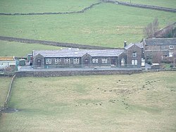
 Colden School (2006) | |
| Location | |
| Grid reference: | SD966287 |
| Location: | 53°45’17"N, 2°3’9"W |
| Data | |
| Postcode: | HX7 |
| Local Government | |
| Council: | Calderdale |
Colden is a hamlet in the West Riding of Yorkshire. It consists of scattered houses and farms on high ground west of Heptonstall, above the valley of Colden Water.
Colden School is a junior and infants school established in 1878.
Here, Colden Water is crossed by two old footbridges, possibly dating from the 17th century. Strines Bridge is a packhorse bridge,[1] and lower down a clapper bridge crosses the stream.[2] Both are Grade II listed structures.
The Pennine Way and Calderdale Way both pass through Colden.
References
- ↑ National Heritage List 1133947: Strines Bridge (Grade I listing)
- ↑ National Heritage List 1225939: Hebble Hole Footbridge (Grade II listing)