Stainland: Difference between revisions
Created page with "{{Infobox town |name=Stainland |county=Yorkshire |riding=West |picture=StainlandView.JPG |picture caption=Stainland, as seen from Jagger Green |os grid ref=SE079196 |latitude=..." |
|||
| Line 33: | Line 33: | ||
Its proximity of the [[M62 motorway]] has led to the development of a new residential role of housing people who work in the neighbouring towns. That, in turn, is leading to new pressures for change in the fabric of the village. | Its proximity of the [[M62 motorway]] has led to the development of a new residential role of housing people who work in the neighbouring towns. That, in turn, is leading to new pressures for change in the fabric of the village. | ||
==About the | ==About the village== | ||
Stainland Cross stands on the roadside across from St Andrew's Church. It relocated here in the twentieth century. It is a standing stone carved with a saltire for St Andrew: the block is scooped out in the form of a cup but the cover that was formerly attached to it has been removed. The column is circular and plain without any of that rich, strange sculpture or scroll ornament which antiquarians generally attribute to Saxon or Danish sculptures. Its height from the base to the top of the sculpture is about ten feet, the column does not exceed five feet. Neither history nor tradition have preserved the date or purpose of its construction. | Stainland Cross stands on the roadside across from St Andrew's Church. It relocated here in the twentieth century. It is a standing stone carved with a saltire for St Andrew: the block is scooped out in the form of a cup but the cover that was formerly attached to it has been removed. The column is circular and plain without any of that rich, strange sculpture or scroll ornament which antiquarians generally attribute to Saxon or Danish sculptures. Its height from the base to the top of the sculpture is about ten feet, the column does not exceed five feet. Neither history nor tradition have preserved the date or purpose of its construction. | ||
| Line 44: | Line 44: | ||
[[File:Carr Hall Castle at Night.JPG|right|thumb|200px|Carr Hall Castle]] | [[File:Carr Hall Castle at Night.JPG|right|thumb|200px|Carr Hall Castle]] | ||
Carr Hall Castle,<ref>[http://www.carrhallcastle.co.uk Carr Hall Castle]</ref> located on the edge of Thunnerley Wood in the Holywell Brook valley, was built in the mid-nineteenth century by the Shaw family, local mill owners, to improve the view from their mansion at Shaw Park. It provided a stable block and housing for the bailiff who bred the shire horses for Brookroyd Mills. The building has been restored and modernised since 2002. | |||
==Churches== | ==Churches== | ||
Latest revision as of 08:47, 7 December 2023
| Stainland | |
| Yorkshire West Riding | |
|---|---|
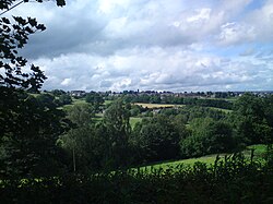
 Stainland, as seen from Jagger Green | |
| Location | |
| Grid reference: | SE079196 |
| Location: | 53°40’22"N, 1°52’50"W |
| Data | |
| Population: | 3,178 (2011) |
| Post town: | Halifax |
| Postcode: | HX4 |
| Dialling code: | 01422 |
| Local Government | |
| Council: | Calderdale |
| Parliamentary constituency: |
Calder Valley |
Stainland is a village in the West Riding of Yorkshire, about two miles west of Elland, three and a half miles south of Halifax and four and a half miles north-west of Huddersfield.
The village'a name comes from Old Norse and means Stony land; the land around Stainland is not very fertile.
Stainland is situated between Holywell Green to the east, to which it is conjoined, and Sowood to the south, and occupies a hilltop position at about 800 feet on a spur which projects from the higher land of Pole Moor and Outlane to the south.
History
The village does not have a separate entry in the Domesday Book.[1]
Early routes and tracks followed high ground to avoid the marshy and wooded valley bottoms and it was on one such high level packhorse route that Stainland developed. The Stainland Cross remains as evidence of man's activity there in the the Middle Ages. An economy that was based principally on wool and textile production led Stainland to develop as a hilltop village, in much the same way as Sowerby and Heptonstall.
With the Industrial Revolution, mills developed in the neighbouring valleys to take advantage of water power, but Stainland continued to act as a focus for the area.
The village continued to thrive, and a number of notable buildings were added to the street scene. With the decline in its agricultural and industrial function, Stainland is now less self-contained than before.
Its proximity of the M62 motorway has led to the development of a new residential role of housing people who work in the neighbouring towns. That, in turn, is leading to new pressures for change in the fabric of the village.
About the village
Stainland Cross stands on the roadside across from St Andrew's Church. It relocated here in the twentieth century. It is a standing stone carved with a saltire for St Andrew: the block is scooped out in the form of a cup but the cover that was formerly attached to it has been removed. The column is circular and plain without any of that rich, strange sculpture or scroll ornament which antiquarians generally attribute to Saxon or Danish sculptures. Its height from the base to the top of the sculpture is about ten feet, the column does not exceed five feet. Neither history nor tradition have preserved the date or purpose of its construction.
On 3 September 1875 The Building News announced that the cross was to be restored according to plans by a "Mr Barber of Halifax."[2] The railings in old images of the cross in its previous position, were probably added by Barber.

Stainland Mechanics' Institute was built by the Shaw family in 1883 by public description, "to improve the moral, social and intellectual habits of the inhabitants". The building was opened by the Mayor of Leeds on 7 June 1884. Over the years it suffered as income declined. By 1952, the trustees decided to sell the building but offered it to the local council. In 1954, a Community Centre was formed, which closed on 18 December 2009 and the building returned to the council, who 2011 sold it.[3]
St Helen's Well at the eastern end of the village is mentioned in John Watson's monumental The History and Antiquities of the Parish of Halifax, 1775. He gives no description but says a Roman Catholic chapel dedicated to Saint Helen, nearby had been converted into a cottage, but in its walls was a large stone known locally as 'the Cross'. Strangers, presumed to be Catholics, made pilgrimages to the well. Watson also possessed a deed which mentioned a grant made to Henry de Sacro Fonte de Staynland. dated between 1279 and 1324. The well was restored in 1843 in response to interest in drinking 'spa' water. The 'Halifax Guardian' for September 1842 described the scene around Well Head spa where crowds carrying drinking utensils jostled each other in their eagerness to take the waters. Well Head was the most popular of the Halifax spas but several other springs in the area were frequented. Similar scenes may have occurred around Stainland's well. In the late 19th century the well was declining. The stone trough had cracked and was leaking. Local placenames reflect the importance of the well. The eastern end of the village is known as Holywell Green, there is a public house called 'The Holywell Inn' and a 'St Helen's Court'. The well was further restored in 1977 and the crumbling trough of the woodcut has been replaced by a solid modern one, no water flows into it.

Carr Hall Castle,[4] located on the edge of Thunnerley Wood in the Holywell Brook valley, was built in the mid-nineteenth century by the Shaw family, local mill owners, to improve the view from their mansion at Shaw Park. It provided a stable block and housing for the bailiff who bred the shire horses for Brookroyd Mills. The building has been restored and modernised since 2002.
Churches

St Andrew's Church, the Church of England parish church, stands in the centre of the village. It was built c.1755 as a chapel for Stainland, Holywell Green and Sowood. The church tower is visible from Norland and Blackley.
Stainland had three other chapels, Stainland Providence Chapel, Stainland Wesleyan Chapel and a mortuary chapel. The mortuary chapel was next to a graveyard that served the Providence Chapel. All three graveyards remain but only the Providence Chapel remains and was converted into nine houses. The mortuary chapel was demolished after the Providence Chapel became houses. The Wesleyan Chapel was demolished to make way for houses.
Sport

- Athletics: Stainland Lions Running Club
- Bowling: Stainland Bowling Club
- Cricket: Stainland CC
- Football: Stainland United FC
- Rugby: Stainland Stags ARLFC
All are based at Stainland Recreation Ground except for Stainland Lions who are based at Heath RUFC, Greetland.
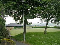
Stainland Recreation Ground (Stainland Rec or the Rec) lies west of the village centre and has two football pitches, a rugby pitch, a cricket ground, a bowling green, a tennis court, a five-a-side pitch, and a playground.
Outside links
| ("Wikimedia Commons" has material about Stainland) |
- Stainland & District Parish Council
- 1885 Restaurant
- Stainland Lions Running Club
- Stainland United FC
- Stainland Stags ARLFC
- Stainland CC
- Stainland CC Cricket Heritage
- Bowling Green Primary School
- Holywell Green Primary School
- The Duke of York
- Carr Hall Castle
References
- ↑ Stainland in the Domesday Book
- ↑ The Building News, 3 September 1875 p.270: "Chips"
- ↑ "End of an era for Victorian landmark". http://www.halifaxcourier.co.uk/news/End-of-an-era-for.6687520.jp. Retrieved 15 January 2011.
- ↑ Carr Hall Castle
