Difference between revisions of "Suffield, Yorkshire"
From Wikishire
(Created page with "{{Infobox town |name=Suffield |county=Yorkshire |riding=North |picture=Farm machinery, Suffield - geograph.org.uk - 220111.jpg |picture caption=Road and farm in Suffield |os g...") |
(No difference)
|
Latest revision as of 19:13, 7 November 2023
| Suffield | |
| Yorkshire North Riding | |
|---|---|
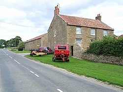
 Road and farm in Suffield | |
| Location | |
| Grid reference: | SE985905 |
| Location: | 54°18’2"N, 0°29’16"W |
| Data | |
| Post town: | Scarborough |
| Postcode: | YO13 |
| Local Government | |
| Council: | North Yorkshire |
| Parliamentary constituency: |
Scarborough and Whitby |
Suffield is a hamlet in the North Riding of Yorkshire, four and a half miles north-west of Scarborough and two miles west of Scalby. It is just inside the boundaries of he North York Moors National Park.
A local cider manufacturer works out of the hamlet.[1]
Outside links
| ("Wikimedia Commons" has material about Suffield, Yorkshire) |
References
- ↑ Rushby, Kevin (19 February 2017). "The Plough at Scalby, North Yorkshire: hotel review". The Guardian. https://www.theguardian.com/travel/2017/feb/19/the-plough-scalby-north-yorkshire-hotel-review. Retrieved 10 January 2019.