Difference between revisions of "Sproatley"
From Wikishire
(Created page with "{{Infobox town |name=Sproatley |county=Yorkshire |riding=East |picture=Boggle Lane, Sproatley.jpg |picture caption=Boggle Lane, Sproatley |os grid ref=TA192346 |latitude=53.79...") |
(No difference)
|
Latest revision as of 18:39, 6 November 2023
| Sproatley | |
| Yorkshire East Riding | |
|---|---|
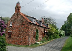
 Boggle Lane, Sproatley | |
| Location | |
| Grid reference: | TA192346 |
| Location: | 53°47’40"N, 0°11’30"W |
| Data | |
| Population: | 1,350 (2011) |
| Post town: | Hull |
| Postcode: | HU11 |
| Dialling code: | 01482 |
| Local Government | |
| Council: | East Riding of Yorkshire |
| Parliamentary constituency: |
Beverley and Holderness |
Sproatley is a village in the East Riding of Yorkshire, seven miles north-east of Kingston upon Hull city centre and four miles north of Hedon, at the junction of the B1238 and B1240 roads.
The village church, St Swithin, is said to contain a small chamber organ built by 'Father' Smith in the late 17th, early 18th century.[1] The church is a Grade II listed building.[2]
The 2011 census recorded a parish a population of 1,350.
Outside links
| ("Wikimedia Commons" has material about Sproatley) |
- Sproatley in the Domesday Book
References
- ↑ "The Organ at St Swithins ...". St Swithins Church, Sproatley. http://www.spanglefish.com/stswithinschurchsproatley/organ.asp. Retrieved 6 November 2013.
- ↑ National Heritage List 1366258: Church of Saint Swithin (Grade II listing)
- Gazetteer — A–Z of Towns Villages and Hamlets. East Riding of Yorkshire Council. 2006. p. 10.