Grimston, North Riding: Difference between revisions
Jump to navigation
Jump to search
Created page with "{{hatnote|''Not to be confused with Grimston in the East Riding}} {{Infobox town |name=Grimston |county=Yorkshire |riding=North |picture=Viewly Hill Fa..." |
No edit summary |
||
| Line 1: | Line 1: | ||
{{hatnote| | {{hatnote|Not to be confused with [[Grimston, Yorkshire|Grimston in the East Riding]]}} | ||
{{Infobox town | {{Infobox town | ||
|name=Grimston | |name=Grimston | ||
Latest revision as of 18:44, 29 August 2023
Not to be confused with Grimston in the East Riding
| Grimston | |
| Yorkshire North Riding | |
|---|---|
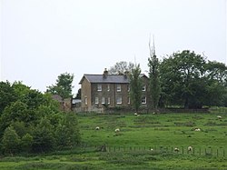
 Farm in Grimston | |
| Location | |
| Grid reference: | SE619754 |
| Location: | 54°10’17"N, 1°3’10"W |
| Data | |
| Population: | 60 |
| Post town: | York |
| Postcode: | YO62 |
| Dialling code: | 01347 |
| Local Government | |
| Council: | North Yorkshire |
| Parliamentary constituency: |
Thirsk and Malton |
Grimstone or Grimston is a hamlet in the North Riding of Yorkshire, close by the B1363 road between York and Helmsley. The village stands in the Howardian Hills just south of the North York Moors National Park and close to Ampleforth Abbey and College. In 2015 the village had an estimated population of 60.
This is a small place, with only about 14 households. Historically, it originates from an old manorial estate, and several of the buildings still hold related names: Grimston Manor, Grimston Manor Farm, Grimston Lodge, Grimston Cottage and Grimston Grange.
Grimston is recorded in the Domesday Book as Grimeston.[1]
| ("Wikimedia Commons" has material about Grimston, North Riding) |
References
- ↑ "Place name: Grimston in East Gilling". The National Archives. http://discovery.nationalarchives.gov.uk/details/r/D7313219. Retrieved 17 January 2019.
