Grimston, Holderness: Difference between revisions
Jump to navigation
Jump to search
Created page with "{{Infobox town |name=Grimston |county=Yorkshire |riding=East |picture=Grimston.jpg |os grid ref=TA279353 |latitude=53.798584 |longitude=-0.058303 |population= |post town=Hull..." |
m RB moved page Grimston, Yorkshire to Grimston, Holderness |
(No difference)
| |
Latest revision as of 18:36, 21 July 2023
| Grimston | |
| Yorkshire East Riding | |
|---|---|

| |
| Location | |
| Grid reference: | TA279353 |
| Location: | 53°47’55"N, 0°3’30"W |
| Data | |
| Post town: | Hull |
| Postcode: | HU11 |
| Dialling code: | 01964 |
| Local Government | |
| Council: | East Riding of Yorkshire |
| Parliamentary constituency: |
Beverley and Holderness |
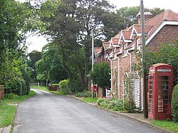
Grimston is a hamlet in the East Riding of Yorkshire, on Holderness, six miles north-west of Withernsea town centre.
The village sits near the North Sea coast, to the east of the B1242 road. To the north, on the coast, is an ancient moated site, dating from the 12th to 14th centuries, formerly the site of a fortified mediæval manor house. It was the seat of the Grimston family until a fire in the mid-17th century.[1]
The family then built a new manor house at Grimston Garth in 18th-century Gothic style. Grimston Garth lies south of the hamlet on a private road. The stable block at Grimston Garth is a Grade II* listed building.[2]
Outside links
| ("Wikimedia Commons" has material about Grimston) |
References
- ↑ National Heritage List 1021241: Two moated sites and associated features north of Grimston Garth (Scheduled ancient monument entry)
- ↑ National Heritage List 1083500: Stable Block at Grimston Garth (Grade II* listing)
- Gazetteer – A–Z of Towns Villages and Hamlets. East Riding of Yorkshire Council. 2006. p. 6.
