Stockbridge, Sussex: Difference between revisions
Jump to navigation
Jump to search
Redirected page to Donnington, Sussex |
No edit summary |
||
| Line 1: | Line 1: | ||
{{Infobox town | |||
|name=Stockbridge | |||
|county=Sussex | |||
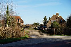
|picture=Stockbridge - geograph.org.uk - 4284494.jpg | |||
|picture caption= | |||
|os grid ref=SU855036 | |||
|latitude=50.82564 | |||
|longitude=-0.786076 | |||
|population= | |||
|census year= | |||
|post town= | |||
|postcode=PO19 | |||
|dialling code= | |||
|LG district=Chichester | |||
|constituency=Chichester | |||
}} | |||
'''Stockbridge''' is a village in the south-west of [[Sussex]], immediately south of [[Chichester]], the [[county town]], and now effectively attached to the city, with the A27 dual carriageway slicing between them. Along its eastern edge lies the [[Chichester Canal]]. | |||
Latest revision as of 13:39, 6 February 2023
| Stockbridge | |
| Sussex | |
|---|---|

| |
| Location | |
| Grid reference: | SU855036 |
| Location: | 50°49’32"N, -0°47’10"W |
| Data | |
| Postcode: | PO19 |
| Local Government | |
| Council: | Chichester |
| Parliamentary constituency: |
Chichester |
Stockbridge is a village in the south-west of Sussex, immediately south of Chichester, the county town, and now effectively attached to the city, with the A27 dual carriageway slicing between them. Along its eastern edge lies the Chichester Canal.