Difference between revisions of "Dallington, Sussex"
From Wikishire
(Created page with "{{Infobox town |name=Dallington |county=Sussex |picture=Dallington Church - geograph.org.uk - 64312.jpg |picture caption=St Giles, Dallington |os grid ref=TQ657190 |latitude=5...") |
(No difference)
|
Revision as of 20:28, 12 January 2023
| Dallington | |
| Sussex | |
|---|---|
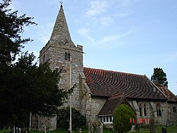
 St Giles, Dallington | |
| Location | |
| Grid reference: | TQ657190 |
| Location: | 50°56’50"N, 0°21’28"E |
| Data | |
| Population: | 292 (Parish, 2011) |
| Post town: | Heathfield |
| Postcode: | TN21 |
| Dialling code: | 01435 |
| Local Government | |
| Council: | Rother |
| Parliamentary constituency: |
Bexhill and Battle |
| Website: | http://www.dallington.net/ |
Dallington is a village in Sussex. It is located eight miles west of Battle and five miles east of Heathfield.
The parish church of St Giles is a Grade II* listed building. The unusual tower and spire date from the early 16th century, but the remainder was rebuilt in 1864 by architects Habershon and Brock[1]
Outside links
| ("Wikimedia Commons" has material about Dallington, Sussex) |
References
- ↑ National Heritage List 1233384: The Parish Church of St Giles (Grade @ listing)