Cross Britain Way: Difference between revisions
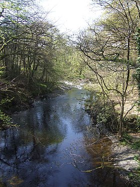
Created page with "right|thumb|280px|The Cross Britain Way by Pont Llogel, Mongomeryshire {{county|Lincolnshire}} Th..." |
(No difference)
|
Latest revision as of 12:30, 6 September 2021

The Cross Britain Way is a hiking trail of 280 miles across the breadth of Great Britain: its eastern starting point is Boston in Lincolnshire, close by the east coast, and its western in Barmouth in Merionethshire, on the west coast.[1]
The route was launched in September 2014 and is one of the Macmillan Ways, a group of paths created to raise funds for Macmillan Cancer Support.[2][3] It is fully waymarked, and a comprehensive guidebook comprising route directions, maps, photographs and an accommodation list has been published and can be obtained from Macmillan Ways Association.[4]
The terrain varies from the flat land of the Great Fen to the Welsh Berwyn Mountains. There is a total of 24,925 feet of ascent, and the highest point reached is at 1,709 feet.[5]
Outside links
- Cross Britain Way on Macmillan Ways
References
- ↑ "Cross Britain Way". ViewRanger. http://my.viewranger.com/route/details/NjA1NDA=. Retrieved 24 September 2015.
- ↑ "Mablethorpe’s ultra runners Chris and Dave cross Britain". Louth Leader. 18 April 2015. http://www.louthleader.co.uk/sport/other-sport/mablethorpe-s-ultra-runners-chris-and-dave-cross-britain-1-6697235. Retrieved 6 August 2015.
- ↑ "Coast to Coast walk through the largest inland county in England". Shropshire Tourism. http://www.shropshiretourism.co.uk/shropshire-news/newarticle.php?id=2718. Retrieved 6 August 2015.
- ↑ "Publications". Macmillan Ways Association. http://www.macmillanway.org/index_files/UK_publications.htm. Retrieved 6 August 2015.
- ↑ Cross Britain Way: Long Distance Walkers Association