Difference between revisions of "Harehill"
From Wikishire
(Created page with "{{Distinguish|Harehills}} {{Infobox town |name=Harehill |county=Derbyshire |picture=The 'Rose and Crown' Boylestone, Derbyshire - geograph.org.uk - 1450318.jpg |picture captio...") |
(No difference)
|
Latest revision as of 20:14, 26 May 2021
- Not to be confused with Harehills
| Harehill | |
| Derbyshire | |
|---|---|
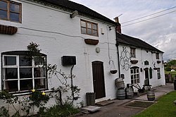
 The 'Rose and Crown', Harehill | |
| Location | |
| Grid reference: | SK174354 |
| Location: | 52°54’60"N, 1°44’28"W |
| Data | |
| Local Government | |
Harehill is a hamlet in the west of Derbyshire, to the south-east of Boylestone. The A515 road nearby.
The nearest town is Uttoxeter to the west across the River Dove in Staffordshire.
The village has a chapel, pub and a group of farms and cottages.
| ("Wikimedia Commons" has material about Harehill) |