Horton, Buckinghamshire: Difference between revisions
m clean up, typos fixed: a 19th century → a 19th-century |
mNo edit summary |
||
| Line 16: | Line 16: | ||
|constituency=Windsor | |constituency=Windsor | ||
}} | }} | ||
'''Horton''' is a village in southern [[Buckinghamshire]], just north of [[Wraysbury]] and sitting squeezed between two reservoirs, the Queen Mother Reservoir to the | '''Horton''' is a village in southern [[Buckinghamshire]], just north of [[Wraysbury]] and sitting squeezed between two reservoirs, the [[Queen Mother Reservoir]] to the north-west and the [[Wraysbury Reservoir]] to the south-east, and with flooded gravel pits overspreading the land between to the south all the way to Wraysbury. | ||
The village is close by the [[Middlesex]] border, here marked by the [[Colne Brook]], across which lies [[Poyle]]. The village of [[Colnbrook]] is to the north. | The village is close by the [[Middlesex]] border, here marked by the [[Colne Brook]], across which lies [[Poyle]]. The village of [[Colnbrook]] is to the north. | ||
Latest revision as of 13:43, 15 September 2020
| Horton | |
| Buckinghamshire | |
|---|---|
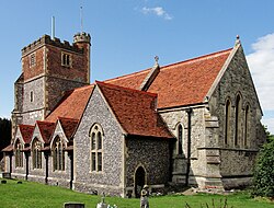
 St Michael and All Angels parish church | |
| Location | |
| Grid reference: | TQ0175 |
| Location: | 51°28’26"N, -0°32’35"W |
| Data | |
| Population: | 983 (2001) |
| Post town: | Slough |
| Postcode: | SL3 |
| Dialling code: | 01753 |
| Local Government | |
| Council: | Windsor and Maidenhead |
| Parliamentary constituency: |
Windsor |
Horton is a village in southern Buckinghamshire, just north of Wraysbury and sitting squeezed between two reservoirs, the Queen Mother Reservoir to the north-west and the Wraysbury Reservoir to the south-east, and with flooded gravel pits overspreading the land between to the south all the way to Wraysbury.
The village is close by the Middlesex border, here marked by the Colne Brook, across which lies Poyle. The village of Colnbrook is to the north.
Geography
Horton stands north of the River Thames, hard by the Middlesex border. The Colne Brook flows through the parish, which runs to the Thames from the River Colne. Wraysbury railway station is nearest its southern end, and Sunnymeads railway station is nearest its western end.
Parish church

The Church of England parish church of St Michael and All Angels has a 12th-century nave,[1] with an ornate Norman arch over the north door in the porch.[2] The north transept is 15th century[1] and the square bell-tower is late 16th century.[2] The aisle, chancel and vestry were rebuilt in 1875–76.[1] The exterior of the church is chequered with brickwork, limestone and flint.
The tower is square and between 70 feet and 80 feet high.[3][4] It has a clock, and the ring of bells was augmented from five to six in 1987.
History and name
The village name, Horton, is a commonplace one. It is Old English in origin and derives from the two words horu ('dirt') and tun ('settlement, farm, estate'), presumably meaning 'farm on muddy soil'.[3] In the Domesday Book of 1086 it was recorded as Hortune.[3][4] The Horton Manor was assessed at 10 hides and held by Walter son of Other.

John Milton, the poet, is one of the more famous former residents of Horton.[3][4][5] His family rented Berkyn Manor, a house that belonged to Sir John Egerton, in the parish between 1632 and 1640 and here wrote many of his poems, including Il Penseroso and L'Allegro. The chancel of St Michael's parish church contains the grave of Milton's mother Sara; and a 19th-century stained glass window on the church commemorates Milton's epic poem Paradise Lost.
The current Berkyn Manor was rebuilt in 1848 by Edward Tyrrell (Remembrancer of the City of London) reputedly on the site of Milton's house.
Outside links
| ("Wikimedia Commons" has material about Horton, Buckinghamshire) |
References
- ↑ 1.0 1.1 1.2 National Heritage List 1117644: Church of St Michael, Stanwell Road
- ↑ 2.0 2.1 Pevsner, Nikolaus (1966). Berkshire. The Buildings of England. Harmondsworth: Penguin Books. p. 171.
- ↑ 3.0 3.1 3.2 3.3 Watts, Victor, ed (2004). The Cambridge Dictionary of English Place-Names, Based on the Collections of the English Place-Name Society. Cambridge: Cambridge University Press.
- ↑ 4.0 4.1 4.2 Gyll, G.W.J. (1862). History of the Parish of Wraysbury, Ankerwycke Priory, and Magna Charta Island; with the History of Horton, and the town of Colnbrook, Bucks.. London: H. G. Bohn. http://books.google.com/books?id=qMcHAAAAQAAJ&pg=PA193. online version at Google Books: OCLC: 5001532
- ↑ Masson, David (1859). The life of John Milton: narrated in connexion with the political, ecclesiastical, and literary history of his time. 1. Boston: Gould and Lincoln. http://books.google.co.uk/books?rview=1&id=Ii4AAAAAYAAJ.