Coldharbour, Surrey: Difference between revisions
Jump to navigation
Jump to search
Created page with "{{Infobox town |name=Coldharbour |county=Surrey |picture=Coldharbour, Surrey - geograph.org.uk - 1403595.jpg |picture caption=Coldharbour |os grid ref=TQ149437 |latitude=51.18..." |
(No difference)
|
Revision as of 20:57, 21 September 2019
| Coldharbour | |
| Surrey | |
|---|---|
 Coldharbour | |
| Location | |
| Grid reference: | TQ149437 |
| Location: | 51°10’52"N, 0°21’26"W |
| Data | |
| Postcode: | RH5 |
| Local Government | |
| Council: | Mole Valley |
| Parliamentary constituency: |
Mole Valley |
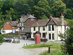
Coldharbour is a hamlet on the Weald in Surrey. It is found on a minor road from Dorking to Leith Hill Place.
This place has a church, Christ Church,[1] The church was built in 1848 by local landowner, John Labouchere of Broome Hall, on land provided by the Duke of Norfolk, to the design of Benjamin Ferrey, a pupil of Augustus Charles Pugin. Along with St James, Abinger, St Mary the Virgin, Holmbury and St John the Evangelist, Wotton, it is a member of the Leith Hill Benefice.
Coldharbour also has a village pub, the Plough Inn.[2]
Outside links
| ("Wikimedia Commons" has material about Surrey Coldharbour, Surrey) |
