Low Force: Difference between revisions
Jump to navigation
Jump to search
Created page with "{{Infobox waterfall |name=Low Force |county 1=Durham |county 2=Yorkshire |picture=Low Force.JPG |picture caption=Low Force Waterfalls |latitude=54.646944 |longitude=-2.151389..." |
mNo edit summary |
||
| Line 10: | Line 10: | ||
|height=18 feet | |height=18 feet | ||
}} | }} | ||
'''Low Force''' is an 18 foot high set of | '''Low Force''' is an 18-foot-high set of waterfalls on the [[River Tees]], which marks the border of the [[North Riding of Yorkshire|North Riding]] of [[Yorkshire]] with [[County Durham]]. | ||
Further upstream is the famous [[High Force]] waterfall. | Further upstream is the famous [[High Force]] waterfall. | ||
Latest revision as of 07:51, 27 June 2019
| Low Force | |
| County Durham, Yorkshire | |
|---|---|
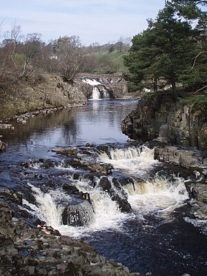
 Low Force Waterfalls | |
| River: | River Tees |
| Fall: | 18 feet |
| Co-ordinates: | 54°38’49"N, 2°9’5"W |
Low Force is an 18-foot-high set of waterfalls on the River Tees, which marks the border of the North Riding of Yorkshire with County Durham.
Further upstream is the famous High Force waterfall.
Low Force is also the site of the Wynch Bridge, completed in 1830. It is suggested that only one person at a time should cross the bridge as it may be unstable.
The falls are within the 'North Pennines Area of Outstanding Natural Beauty' and a European Geopark.