Aberwheeler: Difference between revisions
Created page with "{{Infobox town |name=Aberwheeler |welsh=Aberchwiler |county=Denbighshire |picture=Corner of a lane near Geinas - geograph.org.uk - 1323598.jpg |picture caption=Offa's Dyke Pat..." |
No edit summary |
||
| Line 16: | Line 16: | ||
|constituency=Vale of Clwyd | |constituency=Vale of Clwyd | ||
}} | }} | ||
'''Aberwheeler''' is a village and parish in [[Denbighshire]], four miles north-east of the [[county town]] [[Denbigh]]. The parish is situated in a protrusion of Denbighshire into Flintshire on the south bank of the River Wheeler which here forms the county | '''Aberwheeler''' is a village and parish in [[Denbighshire]], four miles north-east of the [[county town]], [[Denbigh]]. The parish is situated in a protrusion of Denbighshire into [[Flintshire]] on the south bank of the River Wheeler which here forms the county border. At the 2001 census the parish had a population of 327.<ref>{{cite web|title=Census 2001: Parish Headcounts: Denbighshire|url=http://www.neighbourhood.statistics.gov.uk/dissemination/viewFullDataset.do?instanceSelection=03070&productId=779&$ph=60_61&datasetInstanceId=3070&startColumn=1&numberOfColumns=8&containerAreaId=790562|work=Neighbourhood Statistics|publisher=Office for National Statistics|accessdate=9 April 2013}}</ref> | ||
In the east of the parish, the land climbs steeply to the 1,306-ft-high summit of [[Moel y Parc]] on the | In the east of the parish, the land climbs steeply to the 1,306-ft-high summit of [[Moel y Parc]] on the border with [[Flintshire]], where there is a cairn and tumulus. The [[Offa's Dyke Path]], 176 miles long, which runs from [[Sedbury]], in [[Gloucestershire]], to [[Prestatyn]], descends through the parish from the heights of the Clwydian Range to cross the River Wheeler into [[Bodfari]] in [[Flintshire]]. Further north, on the banks of the river, stands Candy Mill, a clover mill built to extract clover seed.<ref>{{cite web|title=Candy Mill with Miller's Cottage and Leat, Aberwheeler|url=http://www.britishlistedbuildings.co.uk/wa-26643-candy-mill-with-miller-s-cottage-and-leat|publisher=British Listed Buildings|accessdate=10 April 2013}}</ref><ref>{{cite web|title=Historic Landscape Characterisation: The Vale of Clwyd: Aberchwiler, Bodfari and Aberwheeler|url=http://www.cpat.org.uk/projects/longer/histland/clwyd/1053.htm|publisher=Clwyd–Powys Archaeological Trust|accessdate=10 April 2013}}</ref> The mill is Grade-II* listed, while Aberwheeler House and Castell Bach are Grade-II listed.<ref>{{cite web|title=Aberwheeler House, Aberwheeler|url=http://www.britishlistedbuildings.co.uk/wa-720-aberwheeler-house-aberwheeler|publisher=British Listed Buildings|accessdate=10 April 2013}}</ref><ref>{{cite web|title=Castell Bach, Aberwheeler|url=http://www.britishlistedbuildings.co.uk/wa-26644-castell-bach-aberwheeler|publisher=British Listed Buildings|accessdate=10 April 2013}}</ref> | ||
== References == | == References == | ||
Latest revision as of 10:02, 29 March 2018
| Aberwheeler Welsh: Aberchwiler | |
| Denbighshire | |
|---|---|
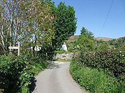
 Offa's Dyke Path in Aberwheeler | |
| Location | |
| Grid reference: | SJ0969 |
| Location: | 53°12’54"N, 3°21’25"W |
| Data | |
| Population: | 327 (2001) |
| Post town: | Denbigh |
| Postcode: | LL16 |
| Dialling code: | 01745 |
| Local Government | |
| Council: | Denbighshire |
| Parliamentary constituency: |
Vale of Clwyd |
Aberwheeler is a village and parish in Denbighshire, four miles north-east of the county town, Denbigh. The parish is situated in a protrusion of Denbighshire into Flintshire on the south bank of the River Wheeler which here forms the county border. At the 2001 census the parish had a population of 327.[1]
In the east of the parish, the land climbs steeply to the 1,306-ft-high summit of Moel y Parc on the border with Flintshire, where there is a cairn and tumulus. The Offa's Dyke Path, 176 miles long, which runs from Sedbury, in Gloucestershire, to Prestatyn, descends through the parish from the heights of the Clwydian Range to cross the River Wheeler into Bodfari in Flintshire. Further north, on the banks of the river, stands Candy Mill, a clover mill built to extract clover seed.[2][3] The mill is Grade-II* listed, while Aberwheeler House and Castell Bach are Grade-II listed.[4][5]
References
- ↑ "Census 2001: Parish Headcounts: Denbighshire". Neighbourhood Statistics. Office for National Statistics. http://www.neighbourhood.statistics.gov.uk/dissemination/viewFullDataset.do?instanceSelection=03070&productId=779&$ph=60_61&datasetInstanceId=3070&startColumn=1&numberOfColumns=8&containerAreaId=790562. Retrieved 9 April 2013.
- ↑ "Candy Mill with Miller's Cottage and Leat, Aberwheeler". British Listed Buildings. http://www.britishlistedbuildings.co.uk/wa-26643-candy-mill-with-miller-s-cottage-and-leat. Retrieved 10 April 2013.
- ↑ "Historic Landscape Characterisation: The Vale of Clwyd: Aberchwiler, Bodfari and Aberwheeler". Clwyd–Powys Archaeological Trust. http://www.cpat.org.uk/projects/longer/histland/clwyd/1053.htm. Retrieved 10 April 2013.
- ↑ "Aberwheeler House, Aberwheeler". British Listed Buildings. http://www.britishlistedbuildings.co.uk/wa-720-aberwheeler-house-aberwheeler. Retrieved 10 April 2013.
- ↑ "Castell Bach, Aberwheeler". British Listed Buildings. http://www.britishlistedbuildings.co.uk/wa-26644-castell-bach-aberwheeler. Retrieved 10 April 2013.
Outside links
This Denbighshire article is a stub: help to improve Wikishire by building it up.