Collooney: Difference between revisions
Jump to navigation
Jump to search
Created page with "{{Infobox town |county=Sligo |gaelic=Cúil Mhuine |picture=Collooney - Looking up main street.jpg |picture caption=Looking up main street |census year=2011 |population=1,369 |..." |
No edit summary |
||
| Line 2: | Line 2: | ||
|county=Sligo | |county=Sligo | ||
|gaelic=Cúil Mhuine | |gaelic=Cúil Mhuine | ||
|picture=Collooney - | |picture=Collooney - Old Mill building.jpg | ||
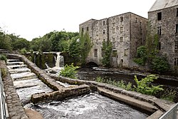
|picture caption= | |picture caption=The Old Mill, Collooney | ||
|census year=2011 | |census year=2011 | ||
|population=1,369 | |population=1,369 | ||
| Line 19: | Line 19: | ||
Collooney is located just off the N4 ([[Dublin]] to [[Sligo]]) and N17 (Sligo to [[Galway]]) roads, having been bypassed twice, by the N4 in 1998, and the N17 in 1992, and is the meeting point of both roads. The town was a significant railway centre, with no less than three railway stations. In addition to the one remaining Collooney railway station, opened on 3 December 1862,<ref>{{cite web | title=Collooney station | work=Railscot - Irish Railways | url=http://www.railscot.co.uk/Ireland/Irish_railways.pdf | accessdate=2007-09-07}}</ref> (on the railway from [[Dublin]] to [[Sligo]]) there was a station on the line to [[Claremorris]] (The Western Railway Corridor) and on the Sligo, Leitrim and Northern Counties Railway line to [[Enniskillen]]. | Collooney is located just off the N4 ([[Dublin]] to [[Sligo]]) and N17 (Sligo to [[Galway]]) roads, having been bypassed twice, by the N4 in 1998, and the N17 in 1992, and is the meeting point of both roads. The town was a significant railway centre, with no less than three railway stations. In addition to the one remaining Collooney railway station, opened on 3 December 1862,<ref>{{cite web | title=Collooney station | work=Railscot - Irish Railways | url=http://www.railscot.co.uk/Ireland/Irish_railways.pdf | accessdate=2007-09-07}}</ref> (on the railway from [[Dublin]] to [[Sligo]]) there was a station on the line to [[Claremorris]] (The Western Railway Corridor) and on the Sligo, Leitrim and Northern Counties Railway line to [[Enniskillen]]. | ||
[[File:Collooney - Looking up main street.jpg|right|thumb|200px|Looking up main street of Collooney]] | |||
==Outside links== | ==Outside links== | ||
*[http://www.sligomethodist.org/collooney.html Collooney Methodist Church] | *[http://www.sligomethodist.org/collooney.html Collooney Methodist Church] | ||
Latest revision as of 11:55, 11 March 2018
| Collooney Gaelic: Cúil Mhuine | |
| County Sligo | |
|---|---|
 The Old Mill, Collooney | |
| Location | |
| Grid reference: | G674261 |
| Location: | 54°10’60"N, 8°30’0"W |
| Data | |
| Population: | 1,369 (2011) |
| Post town: | Collooney |
| Postcode: | F91 |
| Local Government | |
| Council: | Sligo |
| Website: | http://collooneytown.com |
Collooney or Coloony is a town in County Sligo. Its name is from the Irish Cúil Mhuine, meaning 'nook of the thicket'.
Transport
Collooney is located just off the N4 (Dublin to Sligo) and N17 (Sligo to Galway) roads, having been bypassed twice, by the N4 in 1998, and the N17 in 1992, and is the meeting point of both roads. The town was a significant railway centre, with no less than three railway stations. In addition to the one remaining Collooney railway station, opened on 3 December 1862,[1] (on the railway from Dublin to Sligo) there was a station on the line to Claremorris (The Western Railway Corridor) and on the Sligo, Leitrim and Northern Counties Railway line to Enniskillen.

Outside links
References
- ↑ "Collooney station". Railscot - Irish Railways. http://www.railscot.co.uk/Ireland/Irish_railways.pdf. Retrieved 2007-09-07.