Rendezvous Bay Pond: Difference between revisions
No edit summary |
|||
| Line 1: | Line 1: | ||
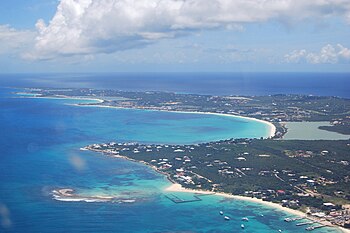
[[File:Anguilla-aerial view western portion.jpg|right|thumb|350px|Rendezvous Bay (middle) and Rendezvous Bay Pond (right)]] | [[File:Anguilla-aerial view western portion.jpg|right|thumb|350px|Rendezvous Bay (middle) and Rendezvous Bay Pond (right)]] | ||
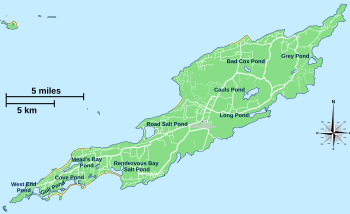
[[File:Anguilla ponds map.svg|right|thumb|350px|Map of Anguilla's ponds]] | [[File:Anguilla ponds map.svg|right|thumb|350px|Map of Anguilla's ponds]] | ||
{{territory| | {{territory|Anguilla}} | ||
'''Rendezvous Bay Pond''', also known as '''Rendezvous Bay Salt Pond''', is a shallow, 59 acre brackish lagoon near the south-western end of the main island of [[Anguilla]]. | '''Rendezvous Bay Pond''', also known as '''Rendezvous Bay Salt Pond''', is a shallow, 59 acre brackish lagoon near the south-western end of the main island of [[Anguilla]]. | ||
The lagoon is an important wetland habitat and denoted as one of the | The lagoon is an important wetland habitat and denoted as one of the territory's 'Important Bird Areas'. | ||
==Description== | ==Description== | ||
| Line 12: | Line 12: | ||
===Birds=== | ===Birds=== | ||
The lagoon was identified as an 'Important Bird Area' by BirdLife International because it supports a small breeding colony of least terns as well as populations of common terns and brown pelicans.<ref name=bli> | The lagoon was identified as an 'Important Bird Area' by BirdLife International because it supports a small breeding colony of least terns as well as populations of common terns and brown pelicans.<ref name=bli>{{iba}}</ref> | ||
==Location== | ==Location== | ||
Latest revision as of 15:58, 9 January 2018


Rendezvous Bay Pond, also known as Rendezvous Bay Salt Pond, is a shallow, 59 acre brackish lagoon near the south-western end of the main island of Anguilla.
The lagoon is an important wetland habitat and denoted as one of the territory's 'Important Bird Areas'.
Description
The pond is on a substrate of marl, on the northern side and sand on the southern. It receives fresh water from rainfall, runoff and a few springs. The pond also receives salt water seepage from the bay through the strip of beach that divides them. It was historically used for salt production.
Vegetation around the pond is sparse, except for stands of buttonwood mangroves (Conocarpus erectus) at its western end. Land at the eastern end is mainly used for grazing livestock.[1]
Birds
The lagoon was identified as an 'Important Bird Area' by BirdLife International because it supports a small breeding colony of least terns as well as populations of common terns and brown pelicans.[1]
Location
- Location map: 18°10’31"N, 63°6’20"W
References
- ↑ 1.0 1.1 Rendezvous Bay Pond IBA: BirdLife International