Difference between revisions of "Hackthorpe"
From Wikishire
(Created page with "{{Infobox town |name=Hackthorpe |county=Westmorland |picture=Hackthorpe Hall. - geograph.org.uk - 88870.jpg |picture caption=Hackthorpe Hall |os grid ref=NY543230 |latitude=54...") |
(No difference)
|
Latest revision as of 20:07, 8 September 2017
| Hackthorpe | |
| Westmorland | |
|---|---|
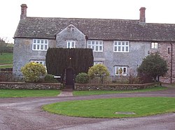
 Hackthorpe Hall | |
| Location | |
| Grid reference: | NY543230 |
| Location: | 54°36’0"N, 2°42’22"W |
| Data | |
| Post town: | Penrith |
| Postcode: | CA10 |
| Dialling code: | 01931 |
| Local Government | |
| Council: | Westmorland & Furness |
| Parliamentary constituency: |
Penrith and The Border |
Hackthorpe is a village in Westmorland, on the A6 road just south of Lowther which the two settlements could be considered to be conjoined. It is about four miles from the town of Penrith (across the county border in Cumberland).
Hackthorpe is almost on the M6 motorway, but there is no access to Hackthorpe from the M6.
| ("Wikimedia Commons" has material about Hackthorpe) |
References
- aboutbritain.com: Hackthorpe