Crosby Garrett: Difference between revisions
Created page with "{{Infobox town |name=Crosby Garrett |picture=St Andrew's Church - geograph.org.uk - 122997.jpg |picture caption=St. Andrew's Church |county=Westmorland |os grid ref=NY728..." |
mNo edit summary |
||
| Line 2: | Line 2: | ||
|name=Crosby Garrett | |name=Crosby Garrett | ||
|picture=St Andrew's Church - geograph.org.uk - 122997.jpg | |picture=St Andrew's Church - geograph.org.uk - 122997.jpg | ||
|picture caption=St | |picture caption=St Andrew's Church | ||
|county=Westmorland | |county=Westmorland | ||
|os grid ref=NY728095 | |os grid ref=NY728095 | ||
| Line 15: | Line 15: | ||
|constituency=Penrith and The Border | |constituency=Penrith and The Border | ||
}} | }} | ||
'''Crosby Garrett''' is a hamlet in [[Westmorland]], three miles | '''Crosby Garrett''' is a hamlet in [[Westmorland]], three miles west of [[Kirkby Stephen]]. | ||
The place-name 'Crosby Garrett' is first attested in a document of 1200, where it appears as ''Crosseby'', and in another of 1206, where it appears as ''Crossebi Gerard''. The first name is Old Scandinavian ''Krossa-byr'', meaning 'village or homestead with crosses'. 'Garrett' is the French personal name, indicating manorial ownership.<ref>{{Ekwall|page=132}}</ref> | The place-name 'Crosby Garrett' is first attested in a document of 1200, where it appears as ''Crosseby'', and in another of 1206, where it appears as ''Crossebi Gerard''. The first name is Old Scandinavian ''Krossa-byr'', meaning 'village or homestead with crosses'. 'Garrett' is the French personal name, indicating manorial ownership.<ref>{{Ekwall|page=132}}</ref> | ||
| Line 24: | Line 24: | ||
The parish contains no settlements of any size other than the village of Crosby Garrett, and much of the parish is on Crosby Garrett Fell to the south-west of the village. | The parish contains no settlements of any size other than the village of Crosby Garrett, and much of the parish is on Crosby Garrett Fell to the south-west of the village. | ||
The [[Settle to Carlisle line|Settle to Carlisle railway]] passes through the parish, at the | The [[Settle to Carlisle line|Settle to Carlisle railway]] passes through the parish, at the south-western edge of the village on the 110-yard Crosby Garrett viaduct. | ||
The highest point in the parish is Nettle Hill at | The highest point in the parish is Nettle Hill at 1,253 feet ({{wmap|54.4642|-2.4384|zoom=14}}). | ||
==Parish church== | ==Parish church== | ||
The parish church of St | The parish church of St Andrew has an Anglo-Saxon chancel, the remainder of the church dates between the 12th and 15th centuries. In 2010, a major restoration project was undertaken. | ||
==Crosby Garrett Helmet== | ==Crosby Garrett Helmet== | ||
Latest revision as of 16:48, 6 September 2017
| Crosby Garrett | |
| Westmorland | |
|---|---|
 St Andrew's Church | |
| Location | |
| Grid reference: | NY728095 |
| Location: | 54°28’51"N, 2°25’13"W |
| Data | |
| Population: | 195 (2011) |
| Post town: | Kirkby Stephen |
| Postcode: | CA17 |
| Dialling code: | 01768 |
| Local Government | |
| Council: | Westmorland & Furness |
| Parliamentary constituency: |
Penrith and The Border |
Crosby Garrett is a hamlet in Westmorland, three miles west of Kirkby Stephen.
The place-name 'Crosby Garrett' is first attested in a document of 1200, where it appears as Crosseby, and in another of 1206, where it appears as Crossebi Gerard. The first name is Old Scandinavian Krossa-byr, meaning 'village or homestead with crosses'. 'Garrett' is the French personal name, indicating manorial ownership.[1]
In May 2010 the Crosby Garrett Helmet, a copper alloy parade helmet dating to Roman Britain, was discovered near the hamlet by a father and son using a metal detector. The helmet was sold to a private buyer at Christie's later that year for £2.3 million.
Description
The parish contains no settlements of any size other than the village of Crosby Garrett, and much of the parish is on Crosby Garrett Fell to the south-west of the village.
The Settle to Carlisle railway passes through the parish, at the south-western edge of the village on the 110-yard Crosby Garrett viaduct.
The highest point in the parish is Nettle Hill at 1,253 feet (54°27’51"N, 2°26’18"W).
Parish church
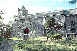
The parish church of St Andrew has an Anglo-Saxon chancel, the remainder of the church dates between the 12th and 15th centuries. In 2010, a major restoration project was undertaken.
Crosby Garrett Helmet

In May 2010 a rare ceremonial Roman helmet was discovered by an unnamed metal detectorist not far from a Roman road near the hamlet. The copper-alloy helmet with integral mask, with the appearance of a youthful male face, and a griffin crest, is only one of three recorded finds of its kind in Britain.[2]
Outside links
| ("Wikimedia Commons" has material about Crosby Garrett) |
- Parishes (East Ward): St Andrew, Crosby Garrett – Curwen, John F: 'The Later Records relating to North Westmorland: or the Barony of Appleby', pp.110-114 (1932)
- Information on Crosby Garrett from GENUKI
References
- ↑ Ekwall, Eilert, The Concise Oxford Dictionary of English Place-Names. Oxford, Oxford University Press, 4th edition, 1960. p. 132 ISBN 0198691033
- ↑ 'Rare Roman helmet and face-mask discovered' The Telegraph, 13 September 2010
