Difference between revisions of "Galligill"
From Wikishire
(Created page with "{{Infobox town |name=Galligill |county=Cumberland |picture=Middle Fell and Galligill - geograph.org.uk - 88281.jpg |picture caption=Middle Fell and Galligill |os grid ref= NY7...") |
(No difference)
|
Latest revision as of 12:05, 14 July 2017
| Galligill | |
| Cumberland | |
|---|---|
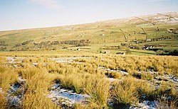
 Middle Fell and Galligill | |
| Location | |
| Grid reference: | NY752450 |
| Location: | 54°47’59"N, 2°23’12"W |
| Data | |
| Postcode: | CA9 |
| Local Government | |
Galligill in the very eastern edge of Cumberland is so scattered a hamlet that it might better be described as a general location, all along a lane up the slope of Middle Fell (on Alston Moor) half a mile to the south of Nenthall and the dale of the River Nent.
Alston is three and a half miles to the north-west of Galligill.
The border of Northumberland is half a mile away, above the dale, close to the meeting of three shires; Cumberland, Northumberland and County Durham.