Arngask: Difference between revisions
Created page with "{{county|Perthshire}} thumb|200px|Arngask parish Kirk taken from Glenfarg green '''Arnga..." |
No edit summary |
||
| Line 2: | Line 2: | ||
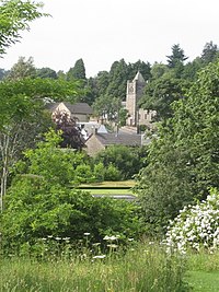
[[File:Arngask parish Kirk taken from Glenfarg green - geograph.org.uk - 1533053.jpg|thumb|200px|Arngask parish Kirk taken from Glenfarg green]] | [[File:Arngask parish Kirk taken from Glenfarg green - geograph.org.uk - 1533053.jpg|thumb|200px|Arngask parish Kirk taken from Glenfarg green]] | ||
'''Arngask''' is a parish in the counties of [[Fife]], [[Kinross-shire|Kinross]], and [[Perthshire|Perth]], containing the villages of [[Glenfarg]] and Duncrivie. It is situated six miles from [[Kinross]] and ten from [[Perth]]. The parish is four miles from east to west, and about three from north to south. It is pleasantly situated in the [[Ochil Hills]] with access to the [[M90 motorway]] which passes right through the centre of the parish. | '''Arngask''' is a parish in the counties of [[Fife]], [[Kinross-shire|Kinross]], and [[Perthshire|Perth]], containing the villages of [[Glenfarg]] and Duncrivie. It is situated six miles from [[Kinross]] and ten from [[Perth]]. The parish is four miles from east to west, and about three from north to south. It is pleasantly situated in the [[Ochil Hills]] with access to the [[M90 motorway]] which passes right through the centre of the parish. | ||
The hamlet of Arngask lies just to the north-east of [[Glenfarg]], in the Perthshire part of the parish. Here lies the ruins of the original parish church. The present parish church in Glenfarg dates from 1906 and was built on the site of a previous structure. It was originally the United Free Church. | |||
The population in 2011 was 1,016. | |||
==Outside links== | |||
*Location map: {{wmap|56.285|-3.407|zoom=13}} | |||
*[http://www.genuki.org.uk/big/sct/FIF/Arngask Arngask] on [[GENUKI]] | |||
{{stub}} | {{stub}} | ||
Latest revision as of 12:47, 5 April 2017

Arngask is a parish in the counties of Fife, Kinross, and Perth, containing the villages of Glenfarg and Duncrivie. It is situated six miles from Kinross and ten from Perth. The parish is four miles from east to west, and about three from north to south. It is pleasantly situated in the Ochil Hills with access to the M90 motorway which passes right through the centre of the parish.
The hamlet of Arngask lies just to the north-east of Glenfarg, in the Perthshire part of the parish. Here lies the ruins of the original parish church. The present parish church in Glenfarg dates from 1906 and was built on the site of a previous structure. It was originally the United Free Church.
The population in 2011 was 1,016.
Outside links
- Location map: 56°17’6"N, 3°24’25"W
- Arngask on GENUKI
This Perthshire article is a stub: help to improve Wikishire by building it up.