Egerton, Cheshire: Difference between revisions
Created page with "{{Infobox town |name=Egerton |county=Cheshire |picture=Sheep pasture near Egerton Green - geograph.org.uk - 712390.jpg |picture caption=Sheep pasture in the north of the civi..." |
No edit summary |
||
| Line 15: | Line 15: | ||
|constituency=Eddisbury | |constituency=Eddisbury | ||
}} | }} | ||
'''Egerton''' is a parish in | '''Egerton''' is a parish in [[Cheshire]] of which the only village is '''Egerton Green'''. It is about four miles north-east of [[Malpas, Cheshire|Malpas]] and eight miles west of [[Nantwich]].<ref name=genuki>{{Genuki|Egerton}}</ref> The population is less than 100. Nearby villages include [[Bickerton, Cheshire|Bickerton]], [[Bulkeley]] and [[No Man's Heath, Cheshire|No Man's Heath]]. | ||
According to the 2001 Census, the parish had a population of 81, and in 2011 it was still under 100. | According to the 2001 Census, the parish had a population of 81, and in 2011 it was still under 100. | ||
Latest revision as of 23:04, 24 January 2017
| Egerton | |
| Cheshire | |
|---|---|
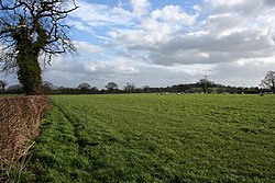
 Sheep pasture in the north of the civil parish | |
| Location | |
| Grid reference: | SJ522520 |
| Location: | 53°3’47"N, 2°42’50"W |
| Data | |
| Population: | 81 (2001) |
| Post town: | Malpas |
| Postcode: | SY14 |
| Dialling code: | 01829 |
| Local Government | |
| Council: | Cheshire East |
| Parliamentary constituency: |
Eddisbury |
Egerton is a parish in Cheshire of which the only village is Egerton Green. It is about four miles north-east of Malpas and eight miles west of Nantwich.[1] The population is less than 100. Nearby villages include Bickerton, Bulkeley and No Man's Heath.
According to the 2001 Census, the parish had a population of 81, and in 2011 it was still under 100.
History
In the Middle Ages, an ancestor of the Sir Roland Egerton, 1st Baronet, William le Belward, took the surname of Egerton from the lordship of Egerton, Cheshire, which he inherited.[2] His descendants, the Egerton family, include the Dukes of Bridgewater and Dukes of Sutherland.
Geography

Egerton is predominantly flat, with an elevation of around 300 feet. Bickerton Road runs through the north, connecting Bickerton School with the A49, and a second lane connects Bickerton Road with the A41. National Cycle Routes 45 and 70 follow the lanes. Bickley Brook runs broadly north–south through the parish. There is a small area of woodland near Egerton Bank Farm in the south of the civil parish.
Landmarks
The parish contains one listed building, the remains of a chapel to the west of Egerton Hall, which chapel was demolished in 1760. The chapel dates from the 14th century, and the remains consist of three sandstone walls, which contain two windows.[3][4]
Outside links
| ("Wikimedia Commons" has material about Egerton, Cheshire) |
References
- ↑ Information on Egerton, Cheshire from GENUKI
- ↑ George Edward Cokayne Complete Baronetage Volume 1 1900
- ↑ National Heritage List 1330098: Remains of Chapel, west of Egerton Hall
- ↑ Nikolaus Pevsner: The Buildings of England: Cheshire, 1971; 2011 Penguin Books ISBN 978-0-300-09588-3
