Stonehouse, Gloucestershire: Difference between revisions
Created page with '{{Infobox town |name=Stonehouse |county=Gloucestershire |picture=TownHall&PO.jpg |picture caption=Town Hall and Post Office |os grid ref=SO805055 |latitude=51.74785 |longitude=-2…' |
mNo edit summary |
||
| Line 8: | Line 8: | ||
|longitude=-2.28386 | |longitude=-2.28386 | ||
|population= | |population= | ||
|post town=Stonehouse | |post town=Stonehouse | ||
|postcode=GL10 | |postcode=GL10 | ||
|dialling code= | |dialling code= | ||
|LG district=Stroud | |||
|constituency=Stroud | |||
}} | }} | ||
'''Stonehouse''' is an industrial town in [[Gloucestershire]]. It is home to a number of factories, such as Dairy Crest, Schlumberger and Dairy Partners. The town is close to the [[M5 motorway]]. | '''Stonehouse''' is an industrial town in [[Gloucestershire]]. It is home to a number of factories, such as Dairy Crest, Schlumberger and Dairy Partners. The town is close to the [[M5 motorway]]. | ||
| Line 29: | Line 29: | ||
Doverow Hill is a former quarry and there are many surrounding hills and a small cliff that looks out onto the whole of Stonehouse. | Doverow Hill is a former quarry and there are many surrounding hills and a small cliff that looks out onto the whole of Stonehouse. | ||
The stone which gave the town its name was replaced by red brick as the builder's material of choice. Due to the availability of raw materials in Stonehouse, brickmaking began there in 1856 with evidence of possible prior brickmaking as early as 1839 or 1840 and of as many as thirteen brickmaking sites altogether. The largest and last to close of the brickmakers, Stonehouse Brick and Tile Company Ltd., was located where the Rosedale housing estate<ref>{{ | The stone which gave the town its name was replaced by red brick as the builder's material of choice. Due to the availability of raw materials in Stonehouse, brickmaking began there in 1856 with evidence of possible prior brickmaking as early as 1839 or 1840 and of as many as thirteen brickmaking sites altogether. The largest and last to close of the brickmakers, Stonehouse Brick and Tile Company Ltd., was located where the Rosedale housing estate<ref>{{wmap|51.745486|-2.277582|zoom=14}}</ref> now stands. It was founded in 1891, and by 1895 employed a large number of people in making pottery, terra-cotta, and bricks. The company closed in 1968 and the 202 foot high chimney was demolished. Bricks and other materials made by the company were not only used locally (notably in the Stonehouse police station<ref>{{wmap|51.746891|-2.282898|zoom=14}}</ref> and post office) and in other areas of Britain, but were also used as far away as Cape Town, [[Gibraltar]], and Buenos Aires, with those used in Gibraltar transported there on the RMS Lusitania during her sea trials.<ref>{{VCH|vol=10|page=276–284}}; {{brithist|15887|Westbury and Whitstone Hundreds}}</ref><ref>[http://www.gsia.org.uk/reprints/1997/gi199714.pdf Wilson, Ray] - ''Stonehouse Brick and Tile Company'' in the Gloucestershire Society for Industrial Archaeology Journal, 1997 pages 14–26]</ref> | ||
==Wycliffe College== | ==Wycliffe College== | ||
| Line 59: | Line 59: | ||
When the threat of world war two became clear in the late 1930s, the Cotswolds were seen as a suitable location for the dispersement of aerospace shadow factories, being a safe place away from German bombers range. Smiths were co-located to Bishops Cleeve and Stonehouse was chosen as a good place to build factories for the manufacturers Sperry's Gyroscope Company, who moved to Bond's Mill and Hoffmann's Bearings located to Oldends Lane. These two factories employed many people during the war and for along time after wards ensuring employment in the town for many years. | When the threat of world war two became clear in the late 1930s, the Cotswolds were seen as a suitable location for the dispersement of aerospace shadow factories, being a safe place away from German bombers range. Smiths were co-located to Bishops Cleeve and Stonehouse was chosen as a good place to build factories for the manufacturers Sperry's Gyroscope Company, who moved to Bond's Mill and Hoffmann's Bearings located to Oldends Lane. These two factories employed many people during the war and for along time after wards ensuring employment in the town for many years. | ||
On 12 September 1940, a lone Dornier flew along the Stroud Valley and photographed the area. Detailed mapping of the Sperry factory was noted by German Intelligence, in preparation for a raid in February 1943, although this never occurred.<ref>http://stonehousehistorygroup.org.uk/page47.html</ref> | On 12 September 1940, a lone Dornier flew along the Stroud Valley and photographed the area. Detailed mapping of the Sperry factory was noted by German Intelligence, in preparation for a raid in February 1943, although this never occurred.<ref>[http://stonehousehistorygroup.org.uk/page47.html Stonehouse History Group]</ref> | ||
===Post War=== | ===Post War=== | ||
Latest revision as of 08:32, 5 June 2016
| Stonehouse | |
| Gloucestershire | |
|---|---|
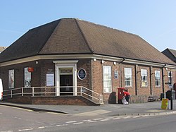
 Town Hall and Post Office | |
| Location | |
| Grid reference: | SO805055 |
| Location: | 51°44’52"N, 2°17’2"W |
| Data | |
| Post town: | Stonehouse |
| Postcode: | GL10 |
| Local Government | |
| Council: | Stroud |
| Parliamentary constituency: |
Stroud |
Stonehouse is an industrial town in Gloucestershire. It is home to a number of factories, such as Dairy Crest, Schlumberger and Dairy Partners. The town is close to the M5 motorway.
The town is situated approximately three miles west of Stroud and twelve miles south of Gloucester. Stonehouse railway station has a regular train service to London.
History
Stonehouse Manor
Stonehouse was mentioned in the Domesday Book written in 1086. Its name is as it appears: a "stone house".
William De Ow, a cousin of William the Conqueror, owned the manor, whose grounds included two mills and a vineyard. In 1327, one of the manor's masters, John Maltravers, was found guilty of involvement in the murder of Edward II in Berkeley Castle, and fled abroad.
The manor house burned down in 1908. Today, on the same site stands Stonehouse Court Hotel, a Grade II listed manor house, which is now a hotel. It is located next to St Cyr's Church and the Stroudwater Canal. One of the original mills remains in operation.
Features
Doverow Hill is a former quarry and there are many surrounding hills and a small cliff that looks out onto the whole of Stonehouse.
The stone which gave the town its name was replaced by red brick as the builder's material of choice. Due to the availability of raw materials in Stonehouse, brickmaking began there in 1856 with evidence of possible prior brickmaking as early as 1839 or 1840 and of as many as thirteen brickmaking sites altogether. The largest and last to close of the brickmakers, Stonehouse Brick and Tile Company Ltd., was located where the Rosedale housing estate[1] now stands. It was founded in 1891, and by 1895 employed a large number of people in making pottery, terra-cotta, and bricks. The company closed in 1968 and the 202 foot high chimney was demolished. Bricks and other materials made by the company were not only used locally (notably in the Stonehouse police station[2] and post office) and in other areas of Britain, but were also used as far away as Cape Town, Gibraltar, and Buenos Aires, with those used in Gibraltar transported there on the RMS Lusitania during her sea trials.[3][4]
Wycliffe College
One of the most well known establishments in the area is Wycliffe College. The school was founded in 1882 by G. W. Sibly as an all-boys school, however it is now co-educational. One of the school's houses, Haywardsend, is one of the town's oldest buildings, an old Tudor farmhouse.
Churches
The town's Parish church is St Cyr's Church, after St Cyriac or St Cyril. George Whitefield, the Gloucester-born evangelist, preached here.
- Church of England: St Cyril's
- Baptist: Stonehous Baptist Church
- Independent: The Bethel Church.
- Methodist: Stonehouse Methodist Church
- Roman Catholic: St Joseph's Catholic
Stonehouse Live is a network of Christians bringing all the Churches together in Stonehouse.[5]
Sport
- Football: Stonehouse Town FC
Pubs
There were thirty-three public houses and beer houses in Stonehouse in 1838, now there are only two. The Woolpack Inn is one of the oldest buildings in Stonehouse (17th century) and is certainly one of the oldest pubs in the town. It was the coaching hostelry for Stonehouse and the coach from Bath stopped there. Further along the High Street is The Globe. The Spa in on Oldends Lane could also be considered one of Stonehouse's local inns.
Growth
Stonehouse development was partly due to good communications for transport, In 1779, the Stroudwater Navigation, (now part of the Thames and Severn Canal) was cut and relics of the canal can still be seen. Ocean Bridge was an iron swing bridge where canal boats would turn. Once there was a repair yard here. Canal restoration is actively underway.
Business increased further when the land was prepared for the opening of the Midland Railway Station in 1844, and the Great Western Railway Station a year later. The Stonehouse and Nailsworth Railway opened a branch to Nailsworth in 1867 and Stroud in 1885.
Second World War
When the threat of world war two became clear in the late 1930s, the Cotswolds were seen as a suitable location for the dispersement of aerospace shadow factories, being a safe place away from German bombers range. Smiths were co-located to Bishops Cleeve and Stonehouse was chosen as a good place to build factories for the manufacturers Sperry's Gyroscope Company, who moved to Bond's Mill and Hoffmann's Bearings located to Oldends Lane. These two factories employed many people during the war and for along time after wards ensuring employment in the town for many years.
On 12 September 1940, a lone Dornier flew along the Stroud Valley and photographed the area. Detailed mapping of the Sperry factory was noted by German Intelligence, in preparation for a raid in February 1943, although this never occurred.[6]
Post War
Rationalisation of the railways happened quickly after the Second World war, with passenger services being suspended on the Stroud and Nailsworth branch in 1947, and to freight in the 1966. The Midland Railway Station was closed in 1965.
Stonehouse was connected to the national motorway network in 1971, when the M5 opened. In the late 20th century, Stonehouse saw substantial growth within industry; large multinationals such as ABB, International Intelligence Limited and Intelligent Armour Limited moving in to the area.
Housing development in Stonehouse continued during the post war period, with the Park Estate being built in the 1950s, and continuing into the 21st century, with the small development at Court View.
21st century
Stonehouse is very well situated for business and business growth due to its central UK location and close proximity to the motorway networks of the M5 & M4. Today Stonehouse has a large number of residential housing estates, including council housing and a small high street.
In 2011, Stonehouse High Street was made into a Community Shared Space, reopening in September 2011.[7]
Outside links

References
- ↑ 51°44’44"N, 2°16’39"W
- ↑ 51°44’49"N, 2°16’58"W
- ↑ A History of the County of Gloucester - Volume pp 276–284: {{{2}}} (Victoria County History); Westbury and Whitstone Hundreds
- ↑ Wilson, Ray - Stonehouse Brick and Tile Company in the Gloucestershire Society for Industrial Archaeology Journal, 1997 pages 14–26]
- ↑ Stonehouse Live
- ↑ Stonehouse History Group
- ↑ "Stonehouse traders fear impact of roadworks". BBC News. 5 May 2011. http://www.bbc.co.uk/news/uk-england-gloucestershire-13294959.