Boot: Difference between revisions
Created page with "{{Infobox town |name=Boot |county=Cumberland |picture=Boot. - geograph.org.uk - 246722.jpg |picture caption=Boot |os grid ref=NY1700 |latitude=54.3982 |longitude=-3.2700 |popu..." |
No edit summary |
||
| Line 16: | Line 16: | ||
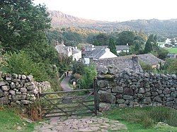
'''Boot''' is a small village in [[Eskdale, Cumberland|Eskdale]], in [[Cumberland]]. The valley is carved by the [[River Esk, Cumberland|River Esk]] through the [[Lake District]], and the village of Boot sits in the dale, in the western part of the Lake District. | '''Boot''' is a small village in [[Eskdale, Cumberland|Eskdale]], in [[Cumberland]]. The valley is carved by the [[River Esk, Cumberland|River Esk]] through the [[Lake District]], and the village of Boot sits in the dale, in the western part of the Lake District. | ||
The village is along just one dead-end lane, which branches off just one road, the sole access to the village. This road is the [[Hardknott Pass]], Britain's steepest road, and it is closed when icy, as often it is during winter. | |||
The village has two pubs: ''The Boot Inn'' (formerly ''The Burnmoor Inn'') and ''The Brook House Inn''. ''The Woolpack Inn - Hardknott Bar & Café'' is only a short walk nearer to Hardknott Pass | The village has two pubs: ''The Boot Inn'' (formerly ''The Burnmoor Inn'') and ''The Brook House Inn''. ''The Woolpack Inn - Hardknott Bar & Café'' is only a short walk nearer to Hardknott Pass | ||
Latest revision as of 21:48, 2 February 2016
| Boot | |
| Cumberland | |
|---|---|
 Boot | |
| Location | |
| Grid reference: | NY1700 |
| Location: | 54°23’54"N, 3°16’12"W |
| Data | |
| Population: | 15 |
| Post town: | Holmrook |
| Postcode: | CA19 |
| Dialling code: | 01946 |
| Local Government | |
| Council: | Cumberland |
| Parliamentary constituency: |
Copeland |
Boot is a small village in Eskdale, in Cumberland. The valley is carved by the River Esk through the Lake District, and the village of Boot sits in the dale, in the western part of the Lake District.
The village is along just one dead-end lane, which branches off just one road, the sole access to the village. This road is the Hardknott Pass, Britain's steepest road, and it is closed when icy, as often it is during winter.
The village has two pubs: The Boot Inn (formerly The Burnmoor Inn) and The Brook House Inn. The Woolpack Inn - Hardknott Bar & Café is only a short walk nearer to Hardknott Pass
The Woolpack Inn has an adjoined brewery known as Hardknott Brewery.
The permanent population of Boot is between 10 and 15, but can rise to between 90 and 120 in summer when the inn and local bed-and-breakfast and holiday cottages are full. These businesses survive on fell walkers, the passengers of the Ravenglass and Eskdale Railway (which stops just than 300 yards from Boot), and holiday-makers from the nearby campsite and cottages. Also in the area is an old boarding house (now available to rent) and a small church, St Catherine's.
On the moorland around one mile north of the village are five stone circles known collectively as the Burnmoor stone circles.[1]
| ("Wikimedia Commons" has material about Boot) |
References
- ↑ Burnmoor Stone Circles, Lake District National Park
